Huanghai geodata
Huanghai (Shandong) is a seat of a third-order administrative division; located in China in Asia/Shanghai (GMT+8) time zone. In our database, there are 1268 cities with bigger population. Compared to other cities in China, 80.2% of cities are located further ↓South; 89.8% of cities are located further ←West and 82.9% of cities have higher elevation than Huanghai. Note1


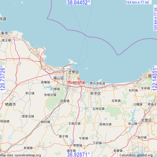
Huanghai GPS coordinates[2]
37° 29' 19.32" North, 121° 26' 25.368" East
| Map corner | latitude | longitude |
|---|---|---|
| Upper-left | 38.04452°, | 120.73726° |
| Center: | 37.4887°, | 121.44038° |
| Lower-right: | 36.92871°, | 122.14351° |
| Map W x H: | 124.1×124.1 km | = 77.1×77.1mi |
| max Lat: | 53.31946° ⇑19.8% North |
| Huanghai: | 37.4887° |
| min Lat: | ⇓80.2% South 18.22056° |
| min Long | Huanghai | max Long |
| 75.07348° | 121.44038° | 134.28917° |
| W 89.8%⇐ | ⇒10.2% E |
Elevation
Elevation of Huanghai is 20 m = 66 ft, and this is 464.8 m = 1525 ft below average elevation for this country.
| Max E: |
5622 m = 18445 ft | 82.9% |
| Avg. | 484.8 m = 1591 ft | |
| Huanghai | 20 m = 66 ft | |
Min E: |
-3 m = -10 ft | 17.1% |
See also: China elevation on elevation.city.
Geographical zone
Huanghai is located in North temperate zone (between Tropic of Cancer and the Arctic Circle). Distance of this Northern Tropic circle is 1562.4 km =970.8 mi to South.| Distance of | km | miles | from Huanghai |
|---|---|---|---|
| North Pole | 5838.7 | 3628 | to North |
| Arctic Circle | 3232.8 | 2008.8 | to North |
| Tropic Cancer | 1562.4 | 970.8 | to South |
| Equator | 4168.4 | 2590.1 | to South |


Nearby cities:
15 places around Huanghai: (largest is in red/bold)
• Binhailu
5.4 km =3.4 mi,  189°
189°
• Fenghuangtai
11.5 km =7.1 mi,  299°
299°
• Jiejiazhuang
11.4 km =7.1 mi,  158°
158°
• Laishan
12 km =7.5 mi,  206°
206°
• Ninghai
18.9 km =11.7 mi,  128°
128°
• Qingyang
16.1 km =10 mi,  272°
272°
• Shihuiyao
6.8 km =4.2 mi,  289°
289°
• Wenhua
17.1 km =10.6 mi, 129°
• Wuning
16.9 km =10.5 mi,  142°
142°
• Xiangyang
6.3 km =3.9 mi,  319°
319°
• Xinfu
12.3 km =7.6 mi, 315°
• Yangmadao
15.4 km =9.6 mi,  103°
103°
• Yantai
1.4 km =0.9 mi,  178°
178°
• Zhichu
12.1 km =7.5 mi, 285°
• Zhifudao
14 km =8.7 mi,  335°
335°
Sources, notices
• [Note1] Compared only with cities in China existing in our database
• [Src1] Map data: © OpenStreetMap contributors (CC-BY-SA)
• [Src2] Other city data from geonames.org with taken over terms of usage.
• [Src3] Geographical zone / Annual Mean Temperature by Robert A. Rohde @ Wikipedia
