Binhailu geodata
Binhailu (Shandong) is a seat of a fourth-order administrative division; located in China in Asia/Shanghai (GMT+8) time zone. In our database, there are 1268 cities with bigger population. Compared to other cities in China, 80.1% of cities are located further ↓South; 89.7% of cities are located further ←West and 88.7% of cities have higher elevation than Binhailu. Note1


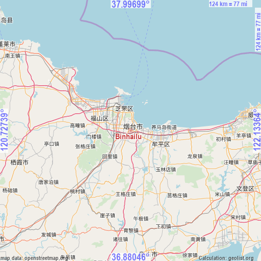
Binhailu GPS coordinates[2]
37° 26' 26.916" North, 121° 25' 49.836" East
| Map corner | latitude | longitude |
|---|---|---|
| Upper-left | 37.99699°, | 120.72739° |
| Center: | 37.44081°, | 121.43051° |
| Lower-right: | 36.88046°, | 122.13364° |
| Map W x H: | 124.1×124.1 km | = 77.1×77.1mi |
| max Lat: | 53.31946° ⇑19.9% North |
| Binhailu: | 37.44081° |
| min Lat: | ⇓80.1% South 18.22056° |
| min Long | Binhailu | max Long |
| 75.07348° | 121.43051° | 134.28917° |
| W 89.7%⇐ | ⇒10.3% E |
Elevation
Elevation of Binhailu is 11 m = 36 ft, and this is 473.8 m = 1554 ft below average elevation for this country.
| Max E: |
5622 m = 18445 ft | 88.7% |
| Avg. | 484.8 m = 1591 ft | |
| Binhailu | 11 m = 36 ft | |
Min E: |
-3 m = -10 ft | 11.3% |
See also: China elevation on elevation.city.
Geographical zone
Binhailu is located in North temperate zone (between Tropic of Cancer and the Arctic Circle). Distance of this Northern Tropic circle is 1557.1 km =967.5 mi to South.| Distance of | km | miles | from Binhailu |
|---|---|---|---|
| North Pole | 5844 | 3631.3 | to North |
| Arctic Circle | 3238.1 | 2012.1 | to North |
| Tropic Cancer | 1557.1 | 967.5 | to South |
| Equator | 4163 | 2586.8 | to South |


Nearby cities:
15 places around Binhailu: (largest is in red/bold)
• Fenghuangtai
14.3 km =8.9 mi,  320°
320°
• Huanghai
5.4 km =3.4 mi,  9°
9°
• Huili
15.5 km =9.6 mi,  219°
219°
• Jiejiazhuang
7.3 km =4.5 mi,  136°
136°
• Laishan
7 km =4.3 mi, 219°
• Ninghai
16.9 km =10.5 mi,  111°
111°
• Qingyang
16.4 km =10.2 mi,  291°
291°
• Shihuiyao
9.4 km =5.8 mi, 324°
• Wenhua
15.1 km =9.4 mi, 111°
• Wuning
13.7 km =8.5 mi,  125°
125°
• Xiangyang
10.6 km =6.6 mi,  342°
342°
• Xinfu
16.1 km =10 mi,  331°
331°
• Yangmadao
15.9 km =9.9 mi,  83°
83°
• Yantai
4.1 km =2.5 mi, 12°
• Zhichu
13.7 km =8.5 mi,  308°
308°
Sources, notices
• [Note1] Compared only with cities in China existing in our database
• [Src1] Map data: © OpenStreetMap contributors (CC-BY-SA)
• [Src2] Other city data from geonames.org with taken over terms of usage.
• [Src3] Geographical zone / Annual Mean Temperature by Robert A. Rohde @ Wikipedia
