Fenghuangtai geodata
Fenghuangtai (Shandong) is a seat of a fourth-order administrative division; located in China in Asia/Shanghai (GMT+8) time zone. In our database, there are 1268 cities with bigger population. Compared to other cities in China, 80.4% of cities are located further ↓South; 89.2% of cities are located further ←West and 73.3% of cities have higher elevation than Fenghuangtai. Note1


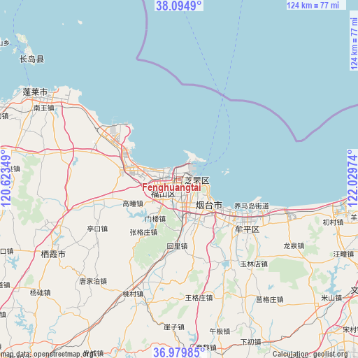
Fenghuangtai GPS coordinates[2]
37° 32' 22.056" North, 121° 19' 35.796" East
| Map corner | latitude | longitude |
|---|---|---|
| Upper-left | 38.0949°, | 120.62349° |
| Center: | 37.53946°, | 121.32661° |
| Lower-right: | 36.97985°, | 122.02974° |
| Map W x H: | 124×124 km | = 77.1×77.1mi |
| max Lat: | 53.31946° ⇑19.6% North |
| Fenghuangtai: | 37.53946° |
| min Lat: | ⇓80.4% South 18.22056° |
| min Long | Fenghuangtai | max Long |
| 75.07348° | 121.32661° | 134.28917° |
| W 89.2%⇐ | ⇒10.8% E |
Elevation
Elevation of Fenghuangtai is 41 m = 135 ft, and this is 443.8 m = 1456 ft below average elevation for this country.
| Max E: |
5622 m = 18445 ft | 73.3% |
| Avg. | 484.8 m = 1591 ft | |
| Fenghuangtai | 41 m = 135 ft | |
Min E: |
-3 m = -10 ft | 26.7% |
See also: China elevation on elevation.city.
Geographical zone
Fenghuangtai is located in North temperate zone (between Tropic of Cancer and the Arctic Circle). Distance of this Northern Tropic circle is 1568.1 km =974.4 mi to South.| Distance of | km | miles | from Fenghuangtai |
|---|---|---|---|
| North Pole | 5833.1 | 3624.5 | to North |
| Arctic Circle | 3227.2 | 2005.3 | to North |
| Tropic Cancer | 1568.1 | 974.4 | to South |
| Equator | 4174 | 2593.6 | to South |


Nearby cities:
15 places around Fenghuangtai: (largest is in red/bold)
• Binhailu
14.3 km =8.9 mi,  140°
140°
• Fuxin
11.4 km =7.1 mi,  263°
263°
• Gaotuan
18.1 km =11.2 mi,  243°
243°
• Guxian
18.4 km =11.4 mi,  281°
281°
• Huanghai
11.5 km =7.1 mi,  119°
119°
• Jiejiazhuang
21.6 km =13.4 mi, 138°
• Laishan
17.1 km =10.6 mi,  163°
163°
• Menlou
15.9 km =9.9 mi,  211°
211°
• Qingyang
7.8 km =4.8 mi,  231°
231°
• Shihuiyao
5 km =3.1 mi,  132°
132°
• Xiangyang
6 km =3.7 mi,  98°
98°
• Xinfu
3.5 km =2.2 mi,  25°
25°
• Yantai
12.3 km =7.6 mi, 124°
• Zhichu
2.9 km =1.8 mi, 213°
• Zhifudao
8.3 km =5.2 mi, 31°
Sources, notices
• [Note1] Compared only with cities in China existing in our database
• [Src1] Map data: © OpenStreetMap contributors (CC-BY-SA)
• [Src2] Other city data from geonames.org with taken over terms of usage.
• [Src3] Geographical zone / Annual Mean Temperature by Robert A. Rohde @ Wikipedia
