Yiminhe geodata
Yiminhe (Inner Mongolia) is a seat of a fourth-order administrative division; located in China in Asia/Shanghai (GMT+8) time zone. In our database, there are 1268 cities with bigger population. Compared to other cities in China, 98.9% of cities are located further ↓South; 80.4% of cities are located further ←West and 79.5% of cities have lower elevation than Yiminhe. Note1


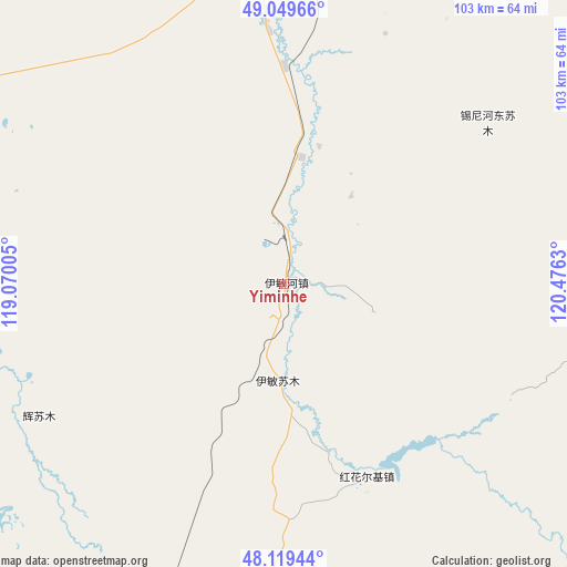
Yiminhe GPS coordinates[2]
48° 35' 12.084" North, 119° 46' 23.412" East
| Map corner | latitude | longitude |
|---|---|---|
| Upper-left | 49.04966°, | 119.07005° |
| Center: | 48.58669°, | 119.77317° |
| Lower-right: | 48.11944°, | 120.4763° |
| Map W x H: | 103.4×103.4 km | = 64.2×64.2mi |
| max Lat: | 53.31946° ⇑1.1% North |
| Yiminhe: | 48.58669° |
| min Lat: | ⇓98.9% South 18.22056° |
| min Long | Yiminhe | max Long |
| 75.07348° | 119.77317° | 134.28917° |
| W 80.4%⇐ | ⇒19.6% E |
Elevation
Elevation of Yiminhe is 670 m = 2198 ft, and this is 185.2 m = 608 ft above average elevation for this country.
| Max E: |
5622 m = 18445 ft | 20.5% |
| Yiminhe | 670 m 2198 ft | |
| Avg. | 484.8 m = 1591 ft | |
Min E: |
-3 m = -10 ft | 79.5% |
See also: China elevation on elevation.city.
Geographical zone
Yiminhe is located in North temperate zone (between Tropic of Cancer and the Arctic Circle). Distance of this North polar circle is 1998.8 km =1242 mi to North.| Distance of | km | miles | from Yiminhe |
|---|---|---|---|
| North Pole | 4604.7 | 2861.2 | to North |
| Arctic Circle | 1998.8 | 1242 | to North |
| Tropic Cancer | 2796.4 | 1737.6 | to South |
| Equator | 5402.3 | 3356.8 | to South |


Nearby cities:
15 places around Yiminhe: (largest is in red/bold)
• Alatan Hada
71.2 km =44.2 mi,  190°
190°
• Baorixile
84.5 km =52.5 mi,  0°
0°
• Bayan Hure
103.3 km =64.2 mi,  349°
349°
• Bayan Tuohai
60.9 km =37.8 mi,  357°
357°
• Bayin Tala Dahan’er Minzu
47.9 km =29.8 mi, 355°
• Fendou
67.9 km =42.2 mi, 359°
• Hailar
68.4 km =42.5 mi, 355°
• Hake
70.2 km =43.6 mi,  18°
18°
• Honghua’erji
38.3 km =23.8 mi,  156°
156°
• Jianshe
74.3 km =46.2 mi, 0°
• Wangong
93.1 km =57.8 mi,  316°
316°
• Wu’erbu Baolige
79 km =49.1 mi,  223°
223°
• Xie’ertala
80.1 km =49.8 mi,  7°
7°
• Xinbaoli Gedong
74.4 km =46.2 mi,  281°
281°
• Xinbaoli Gexi
95 km =59 mi,  252°
252°
Sources, notices
• [Note1] Compared only with cities in China existing in our database
• [Src1] Map data: © OpenStreetMap contributors (CC-BY-SA)
• [Src2] Other city data from geonames.org with taken over terms of usage.
• [Src3] Geographical zone / Annual Mean Temperature by Robert A. Rohde @ Wikipedia
