Ke’erlun geodata
Ke’erlun (Inner Mongolia) is a seat of a fourth-order administrative division; located in China in Asia/Shanghai (GMT+8) time zone. In our database, there are 1268 cities with bigger population. Compared to other cities in China, 98.7% of cities are located further ↓South; 59.2% of cities are located further ←West and 78.1% of cities have lower elevation than Ke’erlun. Note1


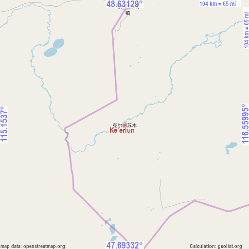
Ke’erlun GPS coordinates[2]
48° 9' 52.02" North, 115° 51' 24.552" East
| Map corner | latitude | longitude |
|---|---|---|
| Upper-left | 48.63129°, | 115.1537° |
| Center: | 48.16445°, | 115.85682° |
| Lower-right: | 47.69332°, | 116.55995° |
| Map W x H: | 104.3×104.3 km | = 64.8×64.8mi |
| max Lat: | 53.31946° ⇑1.3% North |
| Ke’erlun: | 48.16445° |
| min Lat: | ⇓98.7% South 18.22056° |
| min Long | Ke’erlun | max Long |
| 75.07348° | 115.85682° | 134.28917° |
| W 59.2%⇐ | ⇒40.8% E |
Elevation
Elevation of Ke’erlun is 619 m = 2031 ft, and this is 134.2 m = 440 ft above average elevation for this country.
| Max E: |
5622 m = 18445 ft | 21.9% |
| Ke’erlun | 619 m 2031 ft | |
| Avg. | 484.8 m = 1591 ft | |
Min E: |
-3 m = -10 ft | 78.1% |
See also: China elevation on elevation.city.
Geographical zone
Ke’erlun is located in North temperate zone (between Tropic of Cancer and the Arctic Circle). Distance of this North polar circle is 2045.8 km =1271.2 mi to North.| Distance of | km | miles | from Ke’erlun |
|---|---|---|---|
| North Pole | 4651.7 | 2890.4 | to North |
| Arctic Circle | 2045.8 | 1271.2 | to North |
| Tropic Cancer | 2749.5 | 1708.5 | to South |
| Equator | 5355.4 | 3327.7 | to South |


Nearby cities:
15 places around Ke’erlun: (largest is in red/bold)
• Adun Chulu
39.3 km =24.4 mi,  37°
37°
• Alatan'molezhen
89.7 km =55.7 mi,  51°
51°
• Amgalang
173.9 km =108.1 mi,  86°
86°
• Amu Gulang Baolige
170.4 km =105.9 mi,  82°
82°
• A’ershan
98.9 km =61.5 mi, 52°
• Baogede Wula
107.8 km =67 mi,  72°
72°
• Bei’er
120.8 km =75.1 mi,  97°
97°
• Dalai
134.7 km =83.7 mi, 37°
• Dalaidong
163.4 km =101.5 mi,  34°
34°
• E’erdun Wula
108 km =67.1 mi, 38°
• Hangwula
56.1 km =34.9 mi, 52°
• Hulun
96.7 km =60.1 mi,  56°
56°
• Jalai Nur
196.6 km =122.2 mi, 43°
• Jibu Hulangtu
166 km =103.1 mi, 57°
• Saihan Tala
31.1 km =19.3 mi, 47°
Sources, notices
• [Note1] Compared only with cities in China existing in our database
• [Src1] Map data: © OpenStreetMap contributors (CC-BY-SA)
• [Src2] Other city data from geonames.org with taken over terms of usage.
• [Src3] Geographical zone / Annual Mean Temperature by Robert A. Rohde @ Wikipedia
