Hangwula geodata
Hangwula (Inner Mongolia) is a seat of a fourth-order administrative division; located in China in Asia/Shanghai (GMT+8) time zone. In our database, there are 1268 cities with bigger population. Compared to other cities in China, 98.9% of cities are located further ↓South; 62.8% of cities are located further ←West and 77.3% of cities have lower elevation than Hangwula. Note1


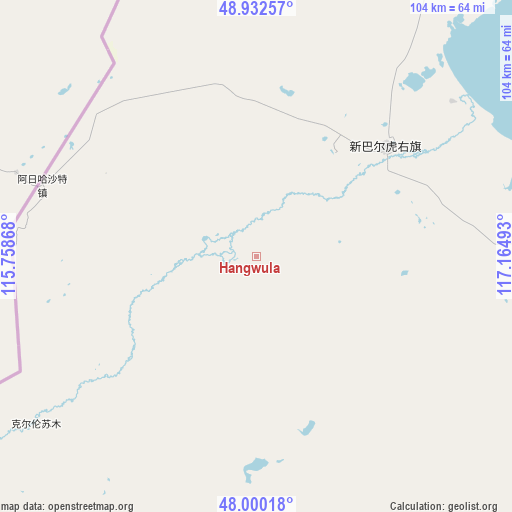
Hangwula GPS coordinates[2]
48° 28' 6.672" North, 116° 27' 42.48" East
| Map corner | latitude | longitude |
|---|---|---|
| Upper-left | 48.93257°, | 115.75868° |
| Center: | 48.46852°, | 116.4618° |
| Lower-right: | 48.00018°, | 117.16493° |
| Map W x H: | 103.7×103.7 km | = 64.4×64.4mi |
| max Lat: | 53.31946° ⇑1.1% North |
| Hangwula: | 48.46852° |
| min Lat: | ⇓98.9% South 18.22056° |
| min Long | Hangwula | max Long |
| 75.07348° | 116.4618° | 134.28917° |
| W 62.8%⇐ | ⇒37.2% E |
Elevation
Elevation of Hangwula is 584 m = 1916 ft, and this is 99.2 m = 325 ft above average elevation for this country.
| Max E: |
5622 m = 18445 ft | 22.7% |
| Hangwula | 584 m 1916 ft | |
| Avg. | 484.8 m = 1591 ft | |
Min E: |
-3 m = -10 ft | 77.3% |
See also: China elevation on elevation.city.
Geographical zone
Hangwula is located in North temperate zone (between Tropic of Cancer and the Arctic Circle). Distance of this North polar circle is 2012 km =1250.2 mi to North.| Distance of | km | miles | from Hangwula |
|---|---|---|---|
| North Pole | 4617.9 | 2869.4 | to North |
| Arctic Circle | 2012 | 1250.2 | to North |
| Tropic Cancer | 2783.3 | 1729.5 | to South |
| Equator | 5389.2 | 3348.7 | to South |


Nearby cities:
15 places around Hangwula: (largest is in red/bold)
• Adun Chulu
20.7 km =12.9 mi,  262°
262°
• Alatan'molezhen
33.7 km =20.9 mi,  49°
49°
• Amgalang
130.7 km =81.2 mi,  100°
100°
• Amu Gulang Baolige
124.5 km =77.4 mi, 95°
• A’ershan
42.9 km =26.7 mi, 52°
• Baogede Wula
58 km =36 mi,  91°
91°
• Bei’er
89.4 km =55.6 mi,  123°
123°
• Dalai
82.1 km =51 mi,  27°
27°
• Dalaidong
111.9 km =69.5 mi, 25°
• E’erdun Wula
55.6 km =34.5 mi,  23°
23°
• Hulun
40.9 km =25.4 mi,  60°
60°
• Jalai Nur
141.7 km =88 mi,  39°
39°
• Jibu Hulangtu
110.2 km =68.5 mi, 59°
• Ke’erlun
56.1 km =34.9 mi,  232°
232°
• Saihan Tala
25.3 km =15.7 mi,  239°
239°
Sources, notices
• [Note1] Compared only with cities in China existing in our database
• [Src1] Map data: © OpenStreetMap contributors (CC-BY-SA)
• [Src2] Other city data from geonames.org with taken over terms of usage.
• [Src3] Geographical zone / Annual Mean Temperature by Robert A. Rohde @ Wikipedia
