Donghongsheng geodata
Donghongsheng (Inner Mongolia) is a seat of a fourth-order administrative division; located in China in Asia/Shanghai (GMT+8) time zone. In our database, there are 1268 cities with bigger population. Compared to other cities in China, 89.8% of cities are located further ↓South; 67.5% of cities are located further →East and 92.6% of cities have lower elevation than Donghongsheng. Note1


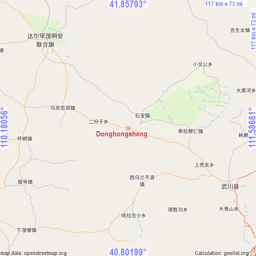
Donghongsheng GPS coordinates[2]
41° 19' 55.56" North, 110° 53' 1.248" East
| Map corner | latitude | longitude |
|---|---|---|
| Upper-left | 41.85793°, | 110.18056° |
| Center: | 41.3321°, | 110.88368° |
| Lower-right: | 40.80199°, | 111.58681° |
| Map W x H: | 117.4×117.4 km | = 72.9×72.9mi |
| max Lat: | 53.31946° ⇑10.2% North |
| Donghongsheng: | 41.3321° |
| min Lat: | ⇓89.8% South 18.22056° |
| min Long | Donghongsheng | max Long |
| 75.07348° | 110.88368° | 134.28917° |
| W 32.5%⇐ | ⇒67.5% E |
Elevation
Elevation of Donghongsheng is 1660 m = 5446 ft, and this is 1175.2 m = 3856 ft above average elevation for this country.
| Max E: |
5622 m = 18445 ft | 7.4% |
| Donghongsheng | 1660 m 5446 ft | |
| Avg. | 484.8 m = 1591 ft | |
Min E: |
-3 m = -10 ft | 92.6% |
See also: China elevation on elevation.city.
Geographical zone
Donghongsheng is located in North temperate zone (between Tropic of Cancer and the Arctic Circle). Distance of this Northern Tropic circle is 1989.8 km =1236.4 mi to South.| Distance of | km | miles | from Donghongsheng |
|---|---|---|---|
| North Pole | 5411.4 | 3362.5 | to North |
| Arctic Circle | 2805.5 | 1743.3 | to North |
| Tropic Cancer | 1989.8 | 1236.4 | to South |
| Equator | 4595.7 | 2855.6 | to South |


Nearby cities:
15 places around Donghongsheng: (largest is in red/bold)
• Butahai
47.9 km =29.8 mi,  264°
264°
• Changhan Mutai
38.7 km =24 mi,  101°
101°
• Damiao
41.3 km =25.7 mi,  229°
229°
• Donggong Cilao
40.5 km =25.2 mi,  248°
248°
• Dongtucheng
39.5 km =24.5 mi,  126°
126°
• Erfenzi
13.6 km =8.5 mi,  285°
285°
• Halamendu
41 km =25.5 mi,  199°
199°
• Har Huxu
39.9 km =24.8 mi,  175°
175°
• Miaogou
51.3 km =31.9 mi, 182°
• Moguyao
46.6 km =29 mi,  143°
143°
• Nalinggou
43.8 km =27.2 mi,  147°
147°
• Shangtuhai
39.5 km =24.5 mi,  115°
115°
• Xihong Shanzi
22.8 km =14.2 mi, 228°
• Xiwulan Bulang
24.8 km =15.4 mi,  163°
163°
• Zhonghouhe
22.4 km =13.9 mi, 136°
Sources, notices
• [Note1] Compared only with cities in China existing in our database
• [Src1] Map data: © OpenStreetMap contributors (CC-BY-SA)
• [Src2] Other city data from geonames.org with taken over terms of usage.
• [Src3] Geographical zone / Annual Mean Temperature by Robert A. Rohde @ Wikipedia
