Yangjia geodata
Yangjia (Heilongjiang) is a seat of a fourth-order administrative division; located in China in Asia/Shanghai (GMT+8) time zone. In our database, there are 1268 cities with bigger population. Compared to other cities in China, 98.4% of cities are located further ↓South; 96.3% of cities are located further ←West and 55.3% of cities have lower elevation than Yangjia. Note1


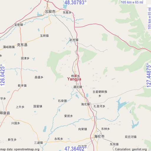
Yangjia GPS coordinates[2]
47° 50' 17.232" North, 126° 44' 44.232" East
| Map corner | latitude | longitude |
|---|---|---|
| Upper-left | 48.30793°, | 126.0425° |
| Center: | 47.83812°, | 126.74562° |
| Lower-right: | 47.36402°, | 127.44875° |
| Map W x H: | 105×105 km | = 65.2×65.2mi |
| max Lat: | 53.31946° ⇑1.6% North |
| Yangjia: | 47.83812° |
| min Lat: | ⇓98.4% South 18.22056° |
| min Long | Yangjia | max Long |
| 75.07348° | 126.74562° | 134.28917° |
| W 96.3%⇐ | ⇒3.7% E |
Elevation
Elevation of Yangjia is 209 m = 686 ft, and this is 275.8 m = 905 ft below average elevation for this country.
| Max E: |
5622 m = 18445 ft | 44.7% |
| Avg. | 484.8 m = 1591 ft | |
| Yangjia | 209 m = 686 ft | |
Min E: |
-3 m = -10 ft | 55.3% |
See also: China elevation on elevation.city.
Geographical zone
Yangjia is located in North temperate zone (between Tropic of Cancer and the Arctic Circle). Distance of this North polar circle is 2082.1 km =1293.8 mi to North.| Distance of | km | miles | from Yangjia |
|---|---|---|---|
| North Pole | 4688 | 2913 | to North |
| Arctic Circle | 2082.1 | 1293.8 | to North |
| Tropic Cancer | 2713.2 | 1685.9 | to South |
| Equator | 5319.1 | 3305.1 | to South |


Nearby cities:
15 places around Yangjia: (largest is in red/bold)
• Aiguo
26.8 km =16.7 mi,  252°
252°
• Aimin
28.3 km =17.6 mi,  190°
190°
• Changfa
37.3 km =23.2 mi,  157°
157°
• Changsheng
25.4 km =15.8 mi,  267°
267°
• Guofu
33.6 km =20.9 mi,  231°
231°
• Haibei
21.1 km =13.1 mi, 160°
• Haixing
15.3 km =9.5 mi,  124°
124°
• Qianfeng
37.9 km =23.5 mi,  259°
259°
• Runjin
37.1 km =23.1 mi,  289°
289°
• Shiquan
19.7 km =12.2 mi,  208°
208°
• Shuanglu
32.2 km =20 mi,  135°
135°
• Shuangqing
29.5 km =18.3 mi,  297°
297°
• Tongbei
7.7 km =4.8 mi,  170°
170°
• Xiangrong
36.7 km =22.8 mi, 171°
• Zhuxing Chaoxianzu
20.8 km =12.9 mi,  126°
126°
Sources, notices
• [Note1] Compared only with cities in China existing in our database
• [Src1] Map data: © OpenStreetMap contributors (CC-BY-SA)
• [Src2] Other city data from geonames.org with taken over terms of usage.
• [Src3] Geographical zone / Annual Mean Temperature by Robert A. Rohde @ Wikipedia
