Xiangrong geodata
Xiangrong (Heilongjiang) is a seat of a fourth-order administrative division; located in China in Asia/Shanghai (GMT+8) time zone. In our database, there are 1268 cities with bigger population. Compared to other cities in China, 97.9% of cities are located further ↓South; 96.4% of cities are located further ←West and 54.8% of cities have lower elevation than Xiangrong. Note1


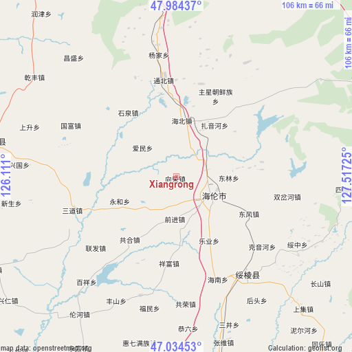
Xiangrong GPS coordinates[2]
47° 30' 41.76" North, 126° 48' 50.832" East
| Map corner | latitude | longitude |
|---|---|---|
| Upper-left | 47.98437°, | 126.111° |
| Center: | 47.5116°, | 126.81412° |
| Lower-right: | 47.03453°, | 127.51725° |
| Map W x H: | 105.6×105.6 km | = 65.6×65.6mi |
| max Lat: | 53.31946° ⇑2.1% North |
| Xiangrong: | 47.5116° |
| min Lat: | ⇓97.9% South 18.22056° |
| min Long | Xiangrong | max Long |
| 75.07348° | 126.81412° | 134.28917° |
| W 96.4%⇐ | ⇒3.6% E |
Elevation
Elevation of Xiangrong is 205 m = 673 ft, and this is 279.8 m = 918 ft below average elevation for this country.
| Max E: |
5622 m = 18445 ft | 45.2% |
| Avg. | 484.8 m = 1591 ft | |
| Xiangrong | 205 m = 673 ft | |
Min E: |
-3 m = -10 ft | 54.8% |
See also: China elevation on elevation.city.
Geographical zone
Xiangrong is located in North temperate zone (between Tropic of Cancer and the Arctic Circle). Distance of this North polar circle is 2118.4 km =1316.3 mi to North.| Distance of | km | miles | from Xiangrong |
|---|---|---|---|
| North Pole | 4724.3 | 2935.5 | to North |
| Arctic Circle | 2118.4 | 1316.3 | to North |
| Tropic Cancer | 2676.9 | 1663.3 | to South |
| Equator | 5282.8 | 3282.6 | to South |


Nearby cities:
15 places around Xiangrong: (largest is in red/bold)
• Aimin
13.2 km =8.2 mi,  310°
310°
• Changfa
9.1 km =5.7 mi,  78°
78°
• Dongfeng
24.6 km =15.3 mi,  117°
117°
• Donglin
15.4 km =9.6 mi,  92°
92°
• Gonghe
23.6 km =14.7 mi,  216°
216°
• Haibei
16.6 km =10.3 mi,  6°
6°
• Hailun
12.1 km =7.5 mi, 120°
• Haixing
28.6 km =17.8 mi,  15°
15°
• Leye
26.4 km =16.4 mi,  157°
157°
• Qianjin
12.7 km =7.9 mi,  180°
180°
• Shiquan
24 km =14.9 mi,  322°
322°
• Shuanglu
22 km =13.7 mi,  52°
52°
• Xiangfu
26.4 km =16.4 mi,  185°
185°
• Yonghe
18.5 km =11.5 mi,  246°
246°
• Zhuxing Chaoxianzu
26.5 km =16.5 mi,  25°
25°
Sources, notices
• [Note1] Compared only with cities in China existing in our database
• [Src1] Map data: © OpenStreetMap contributors (CC-BY-SA)
• [Src2] Other city data from geonames.org with taken over terms of usage.
• [Src3] Geographical zone / Annual Mean Temperature by Robert A. Rohde @ Wikipedia
