Mianchenghuizu geodata
Mianchenghuizu (Hubei) is a seat of a fourth-order administrative division; located in China in Asia/Shanghai (GMT+8) time zone. In our database, there are 1268 cities with bigger population. Compared to other cities in China, 52.1% of cities are located further ↑North; 56.1% of cities are located further →East and 77.7% of cities have higher elevation than Mianchenghuizu. Note1


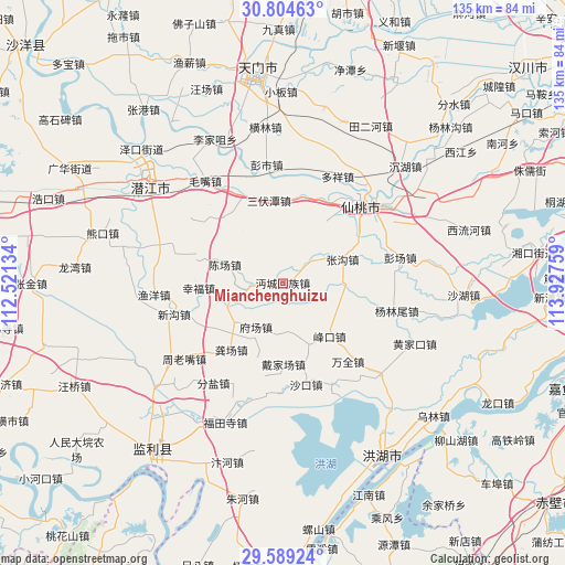
Mianchenghuizu GPS coordinates[2]
30° 11' 55.716" North, 113° 13' 28.056" East
| Map corner | latitude | longitude |
|---|---|---|
| Upper-left | 30.80463°, | 112.52134° |
| Center: | 30.19881°, | 113.22446° |
| Lower-right: | 29.58924°, | 113.92759° |
| Map W x H: | 135.1×135.1 km | = 83.9×83.9mi |
| max Lat: | 53.31946° ⇑52.1% North |
| Mianchenghuizu: | 30.19881° |
| min Lat: | ⇓47.9% South 18.22056° |
| min Long | Mianchenghuizu | max Long |
| 75.07348° | 113.22446° | 134.28917° |
| W 43.9%⇐ | ⇒56.1% E |
Elevation
Elevation of Mianchenghuizu is 31 m = 102 ft, and this is 453.8 m = 1489 ft below average elevation for this country.
| Max E: |
5622 m = 18445 ft | 77.7% |
| Avg. | 484.8 m = 1591 ft | |
| Mianchenghuizu | 31 m = 102 ft | |
Min E: |
-3 m = -10 ft | 22.3% |
See also: China elevation on elevation.city.
Geographical zone
Mianchenghuizu is located in North temperate zone (between Tropic of Cancer and the Arctic Circle). Distance of this Northern Tropic circle is 751.9 km =467.2 mi to South.| Distance of | km | miles | from Mianchenghuizu |
|---|---|---|---|
| North Pole | 6649.3 | 4131.7 | to North |
| Arctic Circle | 4043.4 | 2512.5 | to North |
| Tropic Cancer | 751.9 | 467.2 | to South |
| Equator | 3357.8 | 2086.4 | to South |


Nearby cities:
15 places around Mianchenghuizu: (largest is in red/bold)
• Caoshi
11.9 km =7.4 mi,  184°
184°
• Chenchang
14.8 km =9.2 mi,  287°
287°
• Daijiachang
18.6 km =11.6 mi, 180°
• Fengkou
16.6 km =10.3 mi,  140°
140°
• Fuchang
12.9 km =8 mi,  212°
212°
• Gongchang
20.3 km =12.6 mi,  217°
217°
• Guohe
8.2 km =5.1 mi,  50°
50°
• Huchang
21.2 km =13.2 mi,  20°
20°
• Sanfutan
19.9 km =12.4 mi,  351°
351°
• Shakou
24.7 km =15.3 mi,  166°
166°
• Tonghaikou
7.1 km =4.4 mi,  268°
268°
• Wangshi
15 km =9.3 mi,  229°
229°
• Wanquan
24.4 km =15.2 mi, 140°
• Xingfu
20.2 km =12.6 mi, 266°
• Zhanggou
15.3 km =9.5 mi,  68°
68°
Sources, notices
• [Note1] Compared only with cities in China existing in our database
• [Src1] Map data: © OpenStreetMap contributors (CC-BY-SA)
• [Src2] Other city data from geonames.org with taken over terms of usage.
• [Src3] Geographical zone / Annual Mean Temperature by Robert A. Rohde @ Wikipedia
