Hanchuan geodata
Hanchuan (Hubei) is a populated place; located in China in Asia/Shanghai (GMT+8) time zone. With population of 87,737 people, there are 484 cities with bigger population in this country. Compared to other cities in China, 51.6% of cities are located further ↓South; 52.7% of cities are located further →East and 80.8% of cities have higher elevation than Hanchuan. Note1


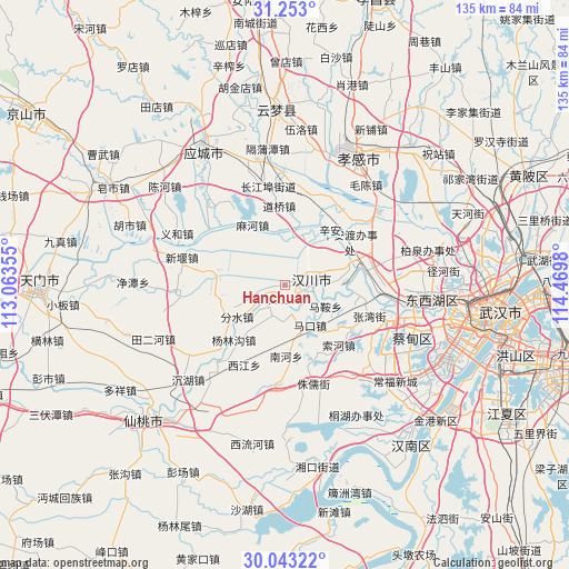
Hanchuan GPS coordinates[2]
30° 39' 0" North, 113° 46' 0.012" East
| Map corner | latitude | longitude |
|---|---|---|
| Upper-left | 31.253°, | 113.06355° |
| Center: | 30.65°, | 113.76667° |
| Lower-right: | 30.04322°, | 114.4698° |
| Map W x H: | 134.5×134.5 km | = 83.6×83.6mi |
| max Lat: | 53.31946° ⇑48.4% North |
| Hanchuan: | 30.65° |
| min Lat: | ⇓51.6% South 18.22056° |
| min Long | Hanchuan | max Long |
| 75.07348° | 113.76667° | 134.28917° |
| W 47.3%⇐ | ⇒52.7% E |
Elevation
Elevation of Hanchuan is 25 m = 82 ft, and this is 459.8 m = 1509 ft below average elevation for this country.
| Max E: |
5622 m = 18445 ft | 80.8% |
| Avg. | 484.8 m = 1591 ft | |
| Hanchuan | 25 m = 82 ft | |
Min E: |
-3 m = -10 ft | 19.2% |
See also: Hanchuan elevation on elevation.city.
Geographical zone
Hanchuan is located in North temperate zone (between Tropic of Cancer and the Arctic Circle). Distance of this Northern Tropic circle is 802 km =498.3 mi to South.| Distance of | km | miles | from Hanchuan |
|---|---|---|---|
| North Pole | 6599.1 | 4100.5 | to North |
| Arctic Circle | 3993.2 | 2481.3 | to North |
| Tropic Cancer | 802 | 498.3 | to South |
| Equator | 3408 | 2117.6 | to South |


Nearby cities:
15 places around Hanchuan: (largest is in red/bold)
• Chenghuang
3.1 km =1.9 mi,  188°
188°
• Daoqiao
18.9 km =11.7 mi,  356°
356°
• Fenshui
13.4 km =8.3 mi,  236°
236°
• Hanji
15.9 km =9.9 mi,  278°
278°
• Liujiage
12.7 km =7.9 mi,  18°
18°
• Mahe
16.4 km =10.2 mi,  332°
332°
• Makou
11.1 km =6.9 mi,  144°
144°
• Ma’an
10.8 km =6.7 mi,  117°
117°
• Miaotou
6.4 km =4 mi,  168°
168°
• Nanhe
17.5 km =10.9 mi,  177°
177°
• Wantan
11.4 km =7.1 mi,  227°
227°
• Xiannüshan
6 km =3.7 mi,  97°
97°
• Xinhe
16.5 km =10.3 mi,  74°
74°
• Xin’andu
18.5 km =11.5 mi,  55°
55°
• Yanglingou
17.6 km =10.9 mi,  222°
222°
Sources, notices
• [Note1] Compared only with cities in China existing in our database
• [Src1] Map data: © OpenStreetMap contributors (CC-BY-SA)
• [Src2] Other city data from geonames.org with taken over terms of usage.
• [Src3] Geographical zone / Annual Mean Temperature by Robert A. Rohde @ Wikipedia
