Yuxian geodata
Yuxian (Hubei) is a seat of a fourth-order administrative division; located in China in Asia/Shanghai (GMT+8) time zone. In our database, there are 1268 cities with bigger population. Compared to other cities in China, 50.6% of cities are located further ↓South; 51.5% of cities are located further →East and 78.8% of cities have higher elevation than Yuxian. Note1


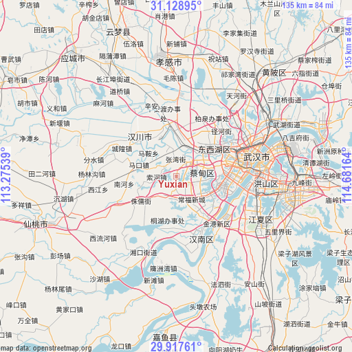
Yuxian GPS coordinates[2]
30° 31' 30.612" North, 113° 58' 42.636" East
| Map corner | latitude | longitude |
|---|---|---|
| Upper-left | 31.12895°, | 113.27539° |
| Center: | 30.52517°, | 113.97851° |
| Lower-right: | 29.91761°, | 114.68164° |
| Map W x H: | 134.7×134.7 km | = 83.7×83.7mi |
| max Lat: | 53.31946° ⇑49.4% North |
| Yuxian: | 30.52517° |
| min Lat: | ⇓50.6% South 18.22056° |
| min Long | Yuxian | max Long |
| 75.07348° | 113.97851° | 134.28917° |
| W 48.5%⇐ | ⇒51.5% E |
Elevation
Elevation of Yuxian is 29 m = 95 ft, and this is 455.8 m = 1495 ft below average elevation for this country.
| Max E: |
5622 m = 18445 ft | 78.8% |
| Avg. | 484.8 m = 1591 ft | |
| Yuxian | 29 m = 95 ft | |
Min E: |
-3 m = -10 ft | 21.2% |
See also: China elevation on elevation.city.
Geographical zone
Yuxian is located in North temperate zone (between Tropic of Cancer and the Arctic Circle). Distance of this Northern Tropic circle is 788.2 km =489.8 mi to South.| Distance of | km | miles | from Yuxian |
|---|---|---|---|
| North Pole | 6613 | 4109.1 | to North |
| Arctic Circle | 4007.1 | 2489.9 | to North |
| Tropic Cancer | 788.2 | 489.8 | to South |
| Equator | 3394.1 | 2109 | to South |


Nearby cities:
15 places around Yuxian: (largest is in red/bold)
• Caidian
8.3 km =5.2 mi,  39°
39°
• Changqing
16.6 km =10.3 mi,  53°
53°
• Daji
6.4 km =4 mi,  106°
106°
• Junshan
16.7 km =10.4 mi,  143°
143°
• Makou
14.7 km =9.1 mi,  289°
289°
• Ma’an
13.9 km =8.6 mi,  310°
310°
• Sheshan
9 km =5.6 mi,  163°
163°
• Suohe
7.8 km =4.8 mi,  267°
267°
• Wujiashan
17.9 km =11.1 mi,  55°
55°
• Xingou
12.6 km =7.8 mi,  1°
1°
• Xinhe
18.7 km =11.6 mi,  346°
346°
• Yong’an
8.5 km =5.3 mi,  214°
214°
• Zhangwan
6.6 km =4.1 mi,  357°
357°
• Zhuru
16.5 km =10.3 mi,  235°
235°
• Zoumaling
14.7 km =9.1 mi,  14°
14°
Sources, notices
• [Note1] Compared only with cities in China existing in our database
• [Src1] Map data: © OpenStreetMap contributors (CC-BY-SA)
• [Src2] Other city data from geonames.org with taken over terms of usage.
• [Src3] Geographical zone / Annual Mean Temperature by Robert A. Rohde @ Wikipedia
