Zoumaling geodata
Zoumaling (Hubei) is a seat of a fourth-order administrative division; located in China in Asia/Shanghai (GMT+8) time zone. In our database, there are 1268 cities with bigger population. Compared to other cities in China, 51.6% of cities are located further ↓South; 51.3% of cities are located further →East and 80.8% of cities have higher elevation than Zoumaling. Note1


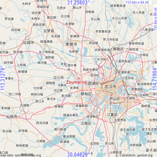
Zoumaling GPS coordinates[2]
30° 39' 10.98" North, 114° 0' 57.276" East
| Map corner | latitude | longitude |
|---|---|---|
| Upper-left | 31.25603°, | 113.31279° |
| Center: | 30.65305°, | 114.01591° |
| Lower-right: | 30.04629°, | 114.71904° |
| Map W x H: | 134.5×134.5 km | = 83.6×83.6mi |
| max Lat: | 53.31946° ⇑48.4% North |
| Zoumaling: | 30.65305° |
| min Lat: | ⇓51.6% South 18.22056° |
| min Long | Zoumaling | max Long |
| 75.07348° | 114.01591° | 134.28917° |
| W 48.7%⇐ | ⇒51.3% E |
Elevation
Elevation of Zoumaling is 25 m = 82 ft, and this is 459.8 m = 1509 ft below average elevation for this country.
| Max E: |
5622 m = 18445 ft | 80.8% |
| Avg. | 484.8 m = 1591 ft | |
| Zoumaling | 25 m = 82 ft | |
Min E: |
-3 m = -10 ft | 19.2% |
See also: China elevation on elevation.city.
Geographical zone
Zoumaling is located in North temperate zone (between Tropic of Cancer and the Arctic Circle). Distance of this Northern Tropic circle is 802.4 km =498.6 mi to South.| Distance of | km | miles | from Zoumaling |
|---|---|---|---|
| North Pole | 6598.8 | 4100.3 | to North |
| Arctic Circle | 3992.9 | 2481.1 | to North |
| Tropic Cancer | 802.4 | 498.6 | to South |
| Equator | 3408.3 | 2117.8 | to South |


Nearby cities:
15 places around Zoumaling: (largest is in red/bold)
• Caidian
7.9 km =4.9 mi,  167°
167°
• Changqing
10.6 km =6.6 mi,  113°
113°
• Daji
16.2 km =10.1 mi, 170°
• Dongshan
13.7 km =8.5 mi,  359°
359°
• Hebaohu
6.8 km =4.2 mi,  322°
322°
• Maomiaoji
13 km =8.1 mi,  48°
48°
• Ma’an
15.1 km =9.4 mi,  249°
249°
• Mintian
14.1 km =8.8 mi,  76°
76°
• Sandian
13 km =8.1 mi,  90°
90°
• Wujiashan
11.8 km =7.3 mi, 109°
• Xingou
3.7 km =2.3 mi,  243°
243°
• Xinhe
8.9 km =5.5 mi,  296°
296°
• Xin’andu
13.2 km =8.2 mi, 319°
• Yuxian
14.7 km =9.1 mi,  194°
194°
• Zhangwan
8.6 km =5.3 mi,  206°
206°
Sources, notices
• [Note1] Compared only with cities in China existing in our database
• [Src1] Map data: © OpenStreetMap contributors (CC-BY-SA)
• [Src2] Other city data from geonames.org with taken over terms of usage.
• [Src3] Geographical zone / Annual Mean Temperature by Robert A. Rohde @ Wikipedia
