Xingou geodata
Xingou (Hubei) is a seat of a fourth-order administrative division; located in China in Asia/Shanghai (GMT+8) time zone. In our database, there are 1268 cities with bigger population. Compared to other cities in China, 51.5% of cities are located further ↓South; 51.5% of cities are located further →East and 78.3% of cities have higher elevation than Xingou. Note1


Xingou GPS coordinates[2]
30° 38' 17.52" North, 113° 58' 54.552" East
| Map corner | latitude | longitude |
|---|---|---|
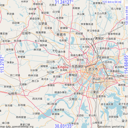
| Upper-left | 31.24127°, | 113.2787° |
| Center: | 30.6382°, | 113.98182° |
| Lower-right: | 30.03135°, | 114.68495° |
| Map W x H: | 134.5×134.5 km | = 83.6×83.6mi |
| max Lat: | 53.31946° ⇑48.5% North |
| Xingou: | 30.6382° |
| min Lat: | ⇓51.5% South 18.22056° |
| min Long | Xingou | max Long |
| 75.07348° | 113.98182° | 134.28917° |
| W 48.5%⇐ | ⇒51.5% E |
Elevation
Elevation of Xingou is 30 m = 98 ft, and this is 454.8 m = 1492 ft below average elevation for this country.
| Max E: |
5622 m = 18445 ft | 78.3% |
| Avg. | 484.8 m = 1591 ft | |
| Xingou | 30 m = 98 ft | |
Min E: |
-3 m = -10 ft | 21.7% |
See also: China elevation on elevation.city.
Geographical zone
Xingou is located in North temperate zone (between Tropic of Cancer and the Arctic Circle). Distance of this Northern Tropic circle is 800.7 km =497.5 mi to South.| Distance of | km | miles | from Xingou |
|---|---|---|---|
| North Pole | 6600.4 | 4101.3 | to North |
| Arctic Circle | 3994.5 | 2482.1 | to North |
| Tropic Cancer | 800.7 | 497.5 | to South |
| Equator | 3406.6 | 2116.8 | to South |


Nearby cities:
15 places around Xingou: (largest is in red/bold)
• Caidian
7.8 km =4.8 mi,  141°
141°
• Changqing
13.2 km =8.2 mi,  101°
101°
• Daji
15.5 km =9.6 mi,  157°
157°
• Dongshan
15.7 km =9.8 mi,  11°
11°
• Hebaohu
7.1 km =4.4 mi,  352°
352°
• Makou
16.2 km =10.1 mi,  241°
241°
• Ma’an
11.5 km =7.1 mi,  251°
251°
• Suohe
15.3 km =9.5 mi,  211°
211°
• Wujiashan
14.5 km =9 mi, 99°
• Xiannüshan
14.6 km =9.1 mi,  271°
271°
• Xinhe
7.3 km =4.5 mi,  320°
320°
• Xin’andu
12.9 km =8 mi,  335°
335°
• Yuxian
12.6 km =7.8 mi,  181°
181°
• Zhangwan
6 km =3.7 mi,  185°
185°
• Zoumaling
3.7 km =2.3 mi,  63°
63°
Sources, notices
• [Note1] Compared only with cities in China existing in our database
• [Src1] Map data: © OpenStreetMap contributors (CC-BY-SA)
• [Src2] Other city data from geonames.org with taken over terms of usage.
• [Src3] Geographical zone / Annual Mean Temperature by Robert A. Rohde @ Wikipedia
