Huzhen geodata
Huzhen (Hubei) is a seat of a fourth-order administrative division; located in China in Asia/Shanghai (GMT+8) time zone. In our database, there are 1268 cities with bigger population. Compared to other cities in China, 53.8% of cities are located further ↓South; 52.7% of cities are located further →East and 81.2% of cities have higher elevation than Huzhen. Note1


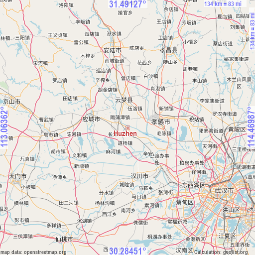
Huzhen GPS coordinates[2]
30° 53' 23.244" North, 113° 46' 0.264" East
| Map corner | latitude | longitude |
|---|---|---|
| Upper-left | 31.49127°, | 113.06362° |
| Center: | 30.88979°, | 113.76674° |
| Lower-right: | 30.28451°, | 114.46987° |
| Map W x H: | 134.2×134.2 km | = 83.4×83.4mi |
| max Lat: | 53.31946° ⇑46.2% North |
| Huzhen: | 30.88979° |
| min Lat: | ⇓53.8% South 18.22056° |
| min Long | Huzhen | max Long |
| 75.07348° | 113.76674° | 134.28917° |
| W 47.3%⇐ | ⇒52.7% E |
Elevation
Elevation of Huzhen is 24 m = 79 ft, and this is 460.8 m = 1512 ft below average elevation for this country.
| Max E: |
5622 m = 18445 ft | 81.2% |
| Avg. | 484.8 m = 1591 ft | |
| Huzhen | 24 m = 79 ft | |
Min E: |
-3 m = -10 ft | 18.8% |
See also: China elevation on elevation.city.
Geographical zone
Huzhen is located in North temperate zone (between Tropic of Cancer and the Arctic Circle). Distance of this Northern Tropic circle is 828.7 km =514.9 mi to South.| Distance of | km | miles | from Huzhen |
|---|---|---|---|
| North Pole | 6572.4 | 4083.9 | to North |
| Arctic Circle | 3966.6 | 2464.7 | to North |
| Tropic Cancer | 828.7 | 514.9 | to South |
| Equator | 3434.6 | 2134.2 | to South |


Nearby cities:
15 places around Huzhen: (largest is in red/bold)
• Changjiangbu
5 km =3.1 mi,  230°
230°
• Daoqiao
8 km =5 mi,  189°
189°
• Dongmafang
7.5 km =4.7 mi,  295°
295°
• Geputan
6.9 km =4.3 mi,  324°
324°
• Guangchang
14.5 km =9 mi,  74°
74°
• Langjun
9.1 km =5.7 mi,  276°
276°
• Langjun
12 km =7.5 mi, 281°
• Liujiage
15.2 km =9.4 mi,  164°
164°
• Mahe
14.3 km =8.9 mi,  211°
211°
• Shahe
7.3 km =4.5 mi,  46°
46°
• Shuyuan
13.2 km =8.2 mi, 74°
• Wolong
12.4 km =7.7 mi,  81°
81°
• Wuluo
11 km =6.8 mi,  20°
20°
• Xiaxindian
9.1 km =5.7 mi,  133°
133°
• Xinhua
13.9 km =8.6 mi, 78°
Sources, notices
• [Note1] Compared only with cities in China existing in our database
• [Src1] Map data: © OpenStreetMap contributors (CC-BY-SA)
• [Src2] Other city data from geonames.org with taken over terms of usage.
• [Src3] Geographical zone / Annual Mean Temperature by Robert A. Rohde @ Wikipedia
