Wolong geodata
Wolong (Hubei) is a seat of a fourth-order administrative division; located in China in Asia/Shanghai (GMT+8) time zone. In our database, there are 1268 cities with bigger population. Compared to other cities in China, 53.9% of cities are located further ↓South; 52% of cities are located further →East and 81.2% of cities have higher elevation than Wolong. Note1


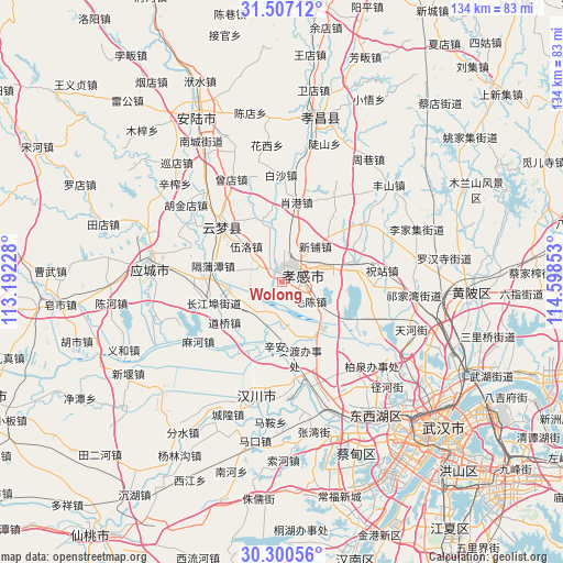
Wolong GPS coordinates[2]
30° 54' 20.664" North, 113° 53' 43.44" East
| Map corner | latitude | longitude |
|---|---|---|
| Upper-left | 31.50712°, | 113.19228° |
| Center: | 30.90574°, | 113.8954° |
| Lower-right: | 30.30056°, | 114.59853° |
| Map W x H: | 134.2×134.2 km | = 83.4×83.4mi |
| max Lat: | 53.31946° ⇑46.1% North |
| Wolong: | 30.90574° |
| min Lat: | ⇓53.9% South 18.22056° |
| min Long | Wolong | max Long |
| 75.07348° | 113.8954° | 134.28917° |
| W 48%⇐ | ⇒52% E |
Elevation
Elevation of Wolong is 24 m = 79 ft, and this is 460.8 m = 1512 ft below average elevation for this country.
| Max E: |
5622 m = 18445 ft | 81.2% |
| Avg. | 484.8 m = 1591 ft | |
| Wolong | 24 m = 79 ft | |
Min E: |
-3 m = -10 ft | 18.8% |
See also: China elevation on elevation.city.
Geographical zone
Wolong is located in North temperate zone (between Tropic of Cancer and the Arctic Circle). Distance of this Northern Tropic circle is 830.5 km =516 mi to South.| Distance of | km | miles | from Wolong |
|---|---|---|---|
| North Pole | 6570.7 | 4082.8 | to North |
| Arctic Circle | 3964.8 | 2463.6 | to North |
| Tropic Cancer | 830.5 | 516 | to South |
| Equator | 3436.4 | 2135.3 | to South |


Nearby cities:
15 places around Wolong: (largest is in red/bold)
• Chezhan
5.6 km =3.5 mi,  25°
25°
• Dougang
15.5 km =9.6 mi,  344°
344°
• Guangchang
2.7 km =1.7 mi,  39°
39°
• Huzhen
12.4 km =7.7 mi,  261°
261°
• Maochen
8.3 km =5.2 mi,  123°
123°
• Pengxing
6.9 km =4.3 mi,  13°
13°
• Sancha
16.2 km =10.1 mi,  74°
74°
• Shahe
7.7 km =4.8 mi,  295°
295°
• Shuyuan
1.8 km =1.1 mi,  15°
15°
• Wuluo
12.1 km =7.5 mi,  315°
315°
• Xiaogan
3.5 km =2.2 mi,  47°
47°
• Xiaxindian
9.8 km =6.1 mi,  215°
215°
• Xihe
15.8 km =9.8 mi, 43°
• Xinhua
1.7 km =1.1 mi, 52°
• Xinpu
11.7 km =7.3 mi, 43°
Sources, notices
• [Note1] Compared only with cities in China existing in our database
• [Src1] Map data: © OpenStreetMap contributors (CC-BY-SA)
• [Src2] Other city data from geonames.org with taken over terms of usage.
• [Src3] Geographical zone / Annual Mean Temperature by Robert A. Rohde @ Wikipedia
