Dongming geodata
Dongming (Heilongjiang) is a seat of a fourth-order administrative division; located in China in Asia/Shanghai (GMT+8) time zone. In our database, there are 1268 cities with bigger population. Compared to other cities in China, 98.1% of cities are located further ↓South; 99.8% of cities are located further ←West and 63.1% of cities have higher elevation than Dongming. Note1


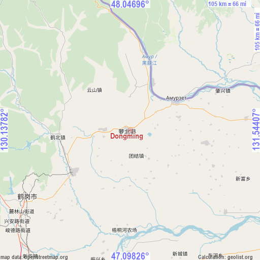
Dongming GPS coordinates[2]
47° 34' 29.136" North, 130° 50' 27.384" East
| Map corner | latitude | longitude |
|---|---|---|
| Upper-left | 48.04696°, | 130.13782° |
| Center: | 47.57476°, | 130.84094° |
| Lower-right: | 47.09826°, | 131.54407° |
| Map W x H: | 105.5×105.5 km | = 65.6×65.6mi |
| max Lat: | 53.31946° ⇑1.9% North |
| Dongming: | 47.57476° |
| min Lat: | ⇓98.1% South 18.22056° |
| min Long | Dongming | max Long |
| 75.07348° | 130.84094° | 134.28917° |
| W 99.8%⇐ | ⇒0.2% E |
Elevation
Elevation of Dongming is 82 m = 269 ft, and this is 402.8 m = 1322 ft below average elevation for this country.
| Max E: |
5622 m = 18445 ft | 63.1% |
| Avg. | 484.8 m = 1591 ft | |
| Dongming | 82 m = 269 ft | |
Min E: |
-3 m = -10 ft | 36.9% |
See also: China elevation on elevation.city.
Geographical zone
Dongming is located in North temperate zone (between Tropic of Cancer and the Arctic Circle). Distance of this North polar circle is 2111.4 km =1312 mi to North.| Distance of | km | miles | from Dongming |
|---|---|---|---|
| North Pole | 4717.2 | 2931.1 | to North |
| Arctic Circle | 2111.4 | 1312 | to North |
| Tropic Cancer | 2683.9 | 1667.7 | to South |
| Equator | 5289.8 | 3286.9 | to South |


Nearby cities:
15 places around Dongming: (largest is in red/bold)
• Dongfanghong
46.9 km =29.1 mi,  234°
234°
• Dongshan
47.4 km =29.5 mi,  237°
237°
• Fengxiang
1.3 km =0.8 mi,  273°
273°
• Gounan
47.4 km =29.5 mi, 239°
• Guangming
49.2 km =30.6 mi, 237°
• Hebei
29.5 km =18.3 mi, 265°
• Hegang
47.7 km =29.6 mi, 238°
• Hongqi
51.7 km =32.1 mi, 236°
• Huanshan
22.1 km =13.7 mi,  318°
318°
• Mingshan
20.8 km =12.9 mi,  56°
56°
• Shuyuan
50.5 km =31.4 mi, 238°
• Tiexi
51.3 km =31.9 mi, 235°
• Tuanjie
10.3 km =6.4 mi,  167°
167°
• Xing’an
59.3 km =36.8 mi, 231°
• Zhenxing
54.1 km =33.6 mi,  194°
194°
Sources, notices
• [Note1] Compared only with cities in China existing in our database
• [Src1] Map data: © OpenStreetMap contributors (CC-BY-SA)
• [Src2] Other city data from geonames.org with taken over terms of usage.
• [Src3] Geographical zone / Annual Mean Temperature by Robert A. Rohde @ Wikipedia
