Boli geodata
Boli (Heilongjiang) is a seat of a third-order administrative division; located in China in Asia/Shanghai (GMT+8) time zone. With population of 95,260 people, there are 444 cities with bigger population in this country. Compared to other cities in China, 94.7% of cities are located further ↓South; 99.6% of cities are located further ←West and 56.2% of cities have lower elevation than Boli. Note1


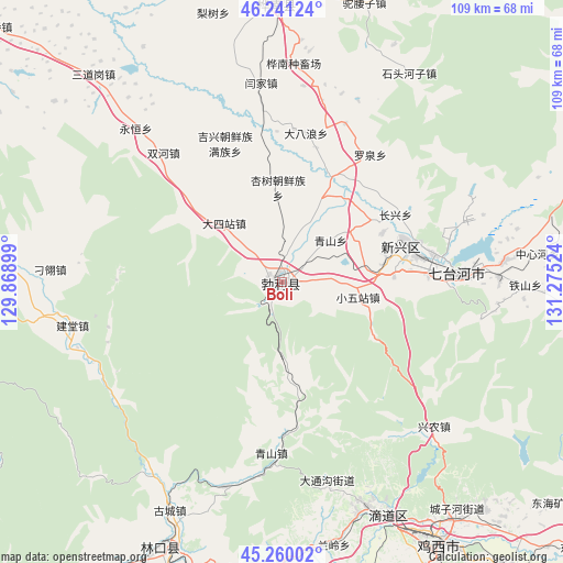
Boli GPS coordinates[2]
45° 45' 10.044" North, 130° 34' 19.596" East
| Map corner | latitude | longitude |
|---|---|---|
| Upper-left | 46.24124°, | 129.86899° |
| Center: | 45.75279°, | 130.57211° |
| Lower-right: | 45.26002°, | 131.27524° |
| Map W x H: | 109.1×109.1 km | = 67.8×67.8mi |
| max Lat: | 53.31946° ⇑5.3% North |
| Boli: | 45.75279° |
| min Lat: | ⇓94.7% South 18.22056° |
| min Long | Boli | max Long |
| 75.07348° | 130.57211° | 134.28917° |
| W 99.6%⇐ | ⇒0.40000000000001% E |
Elevation
Elevation of Boli is 218 m = 715 ft, and this is 266.8 m = 875 ft below average elevation for this country.
| Max E: |
5622 m = 18445 ft | 43.8% |
| Avg. | 484.8 m = 1591 ft | |
| Boli | 218 m = 715 ft | |
Min E: |
-3 m = -10 ft | 56.2% |
See also: Boli elevation on elevation.city.
Geographical zone
Boli is located in North temperate zone (between Tropic of Cancer and the Arctic Circle). Distance of this North polar circle is 2313.9 km =1437.8 mi to North.| Distance of | km | miles | from Boli |
|---|---|---|---|
| North Pole | 4919.8 | 3057 | to North |
| Arctic Circle | 2313.9 | 1437.8 | to North |
| Tropic Cancer | 2481.3 | 1541.8 | to South |
| Equator | 5087.2 | 3161 | to South |


Nearby cities:
15 places around Boli: (largest is in red/bold)
• Beishan
28.5 km =17.7 mi,  75°
75°
• Dasizhan
16 km =9.9 mi,  315°
315°
• Hongqi
23.9 km =14.9 mi,  74°
74°
• Jixing
29 km =18 mi,  337°
337°
• Qiangken
17 km =10.6 mi,  24°
24°
• Qingshan
12.4 km =7.7 mi,  48°
48°
• Shuanghe
33.9 km =21.1 mi, 317°
• Taihecun
21.6 km =13.4 mi,  86°
86°
• Wanbaohe
30.9 km =19.2 mi, 85°
• Woken
27.8 km =17.3 mi,  350°
350°
• Xiaowuzhan
15.1 km =9.4 mi,  101°
101°
• Xingnong
40.4 km =25.1 mi,  133°
133°
• Xingshu
18.7 km =11.6 mi,  357°
357°
• Yahe
41.3 km =25.7 mi,  195°
195°
• Yanjia
38.9 km =24.2 mi, 353°
Sources, notices
• [Note1] Compared only with cities in China existing in our database
• [Src1] Map data: © OpenStreetMap contributors (CC-BY-SA)
• [Src2] Other city data from geonames.org with taken over terms of usage.
• [Src3] Geographical zone / Annual Mean Temperature by Robert A. Rohde @ Wikipedia
