Geshan geodata
Geshan (Heilongjiang) is a seat of a fourth-order administrative division; located in China in Asia/Shanghai (GMT+8) time zone. In our database, there are 1268 cities with bigger population. Compared to other cities in China, 97.5% of cities are located further ↓South; 97.2% of cities are located further ←West and 56.5% of cities have lower elevation than Geshan. Note1


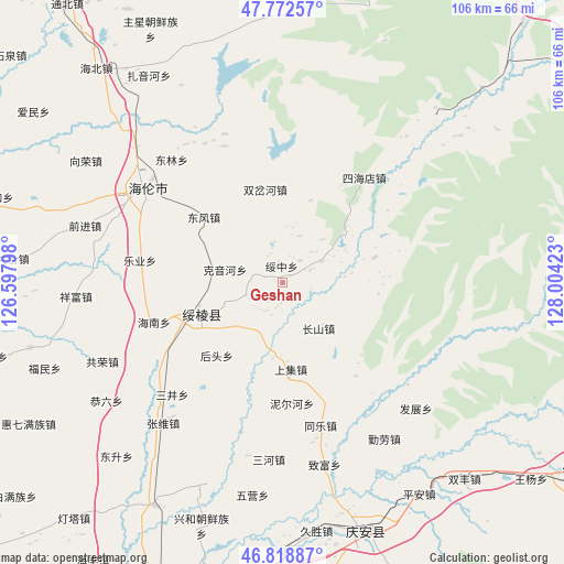
Geshan GPS coordinates[2]
47° 17' 52.332" North, 127° 18' 3.96" East
| Map corner | latitude | longitude |
|---|---|---|
| Upper-left | 47.77257°, | 126.59798° |
| Center: | 47.29787°, | 127.3011° |
| Lower-right: | 46.81887°, | 128.00423° |
| Map W x H: | 106×106 km | = 65.9×65.9mi |
| max Lat: | 53.31946° ⇑2.5% North |
| Geshan: | 47.29787° |
| min Lat: | ⇓97.5% South 18.22056° |
| min Long | Geshan | max Long |
| 75.07348° | 127.3011° | 134.28917° |
| W 97.2%⇐ | ⇒2.8% E |
Elevation
Elevation of Geshan is 221 m = 725 ft, and this is 263.8 m = 865 ft below average elevation for this country.
| Max E: |
5622 m = 18445 ft | 43.5% |
| Avg. | 484.8 m = 1591 ft | |
| Geshan | 221 m = 725 ft | |
Min E: |
-3 m = -10 ft | 56.5% |
See also: China elevation on elevation.city.
Geographical zone
Geshan is located in North temperate zone (between Tropic of Cancer and the Arctic Circle). Distance of this North polar circle is 2142.1 km =1331 mi to North.| Distance of | km | miles | from Geshan |
|---|---|---|---|
| North Pole | 4748 | 2950.3 | to North |
| Arctic Circle | 2142.1 | 1331 | to North |
| Tropic Cancer | 2653.1 | 1648.6 | to South |
| Equator | 5259 | 3267.8 | to South |


Nearby cities:
15 places around Geshan: (largest is in red/bold)
• Changshan
11 km =6.8 mi,  144°
144°
• Dongfeng
19.4 km =12.1 mi,  310°
310°
• Donglin
31.3 km =19.4 mi,  317°
317°
• Hainan
25.2 km =15.7 mi,  253°
253°
• Houtou
18.4 km =11.4 mi,  222°
222°
• Kaoshan
14.8 km =9.2 mi,  236°
236°
• Keyinhe
10.4 km =6.5 mi,  283°
283°
• Leye
26.7 km =16.6 mi,  268°
268°
• Sanjing
29.6 km =18.4 mi, 224°
• Shangji
16.3 km =10.1 mi,  174°
174°
• Shuangchahe
17.9 km =11.1 mi,  350°
350°
• Sihaidian
24.9 km =15.5 mi,  38°
38°
• Suileng
16.5 km =10.3 mi, 250°
• Suizhong
3.3 km =2.1 mi,  359°
359°
• Tongle
27.7 km =17.2 mi, 165°
Sources, notices
• [Note1] Compared only with cities in China existing in our database
• [Src1] Map data: © OpenStreetMap contributors (CC-BY-SA)
• [Src2] Other city data from geonames.org with taken over terms of usage.
• [Src3] Geographical zone / Annual Mean Temperature by Robert A. Rohde @ Wikipedia
