Sihaidian geodata
Sihaidian (Heilongjiang) is a seat of a fourth-order administrative division; located in China in Asia/Shanghai (GMT+8) time zone. In our database, there are 1268 cities with bigger population. Compared to other cities in China, 97.9% of cities are located further ↓South; 97.6% of cities are located further ←West and 59.8% of cities have lower elevation than Sihaidian. Note1


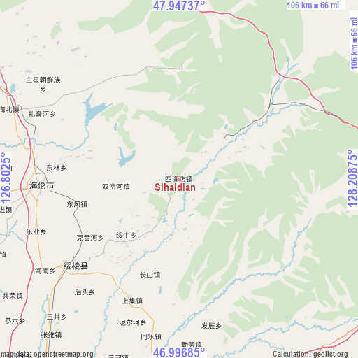
Sihaidian GPS coordinates[2]
47° 28' 27.336" North, 127° 30' 20.232" East
| Map corner | latitude | longitude |
|---|---|---|
| Upper-left | 47.94737°, | 126.8025° |
| Center: | 47.47426°, | 127.50562° |
| Lower-right: | 46.99685°, | 128.20875° |
| Map W x H: | 105.7×105.7 km | = 65.7×65.7mi |
| max Lat: | 53.31946° ⇑2.1% North |
| Sihaidian: | 47.47426° |
| min Lat: | ⇓97.9% South 18.22056° |
| min Long | Sihaidian | max Long |
| 75.07348° | 127.50562° | 134.28917° |
| W 97.6%⇐ | ⇒2.4% E |
Elevation
Elevation of Sihaidian is 257 m = 843 ft, and this is 227.8 m = 747 ft below average elevation for this country.
| Max E: |
5622 m = 18445 ft | 40.2% |
| Avg. | 484.8 m = 1591 ft | |
| Sihaidian | 257 m = 843 ft | |
Min E: |
-3 m = -10 ft | 59.8% |
See also: China elevation on elevation.city.
Geographical zone
Sihaidian is located in North temperate zone (between Tropic of Cancer and the Arctic Circle). Distance of this North polar circle is 2122.5 km =1318.9 mi to North.| Distance of | km | miles | from Sihaidian |
|---|---|---|---|
| North Pole | 4728.4 | 2938.1 | to North |
| Arctic Circle | 2122.5 | 1318.9 | to North |
| Tropic Cancer | 2672.7 | 1660.7 | to South |
| Equator | 5278.6 | 3280 | to South |


Nearby cities:
15 places around Sihaidian: (largest is in red/bold)
• Changfa
43.4 km =27 mi,  277°
277°
• Changshan
30 km =18.6 mi,  197°
197°
• Dongfeng
31 km =19.3 mi,  256°
256°
• Donglin
36.7 km =22.8 mi, 275°
• Fazhan
44.2 km =27.5 mi,  167°
167°
• Geshan
24.9 km =15.5 mi,  218°
218°
• Hailun
41.5 km =25.8 mi,  267°
267°
• Houtou
43.3 km =26.9 mi, 219°
• Kaoshan
39.2 km =24.4 mi, 224°
• Keyinhe
30.7 km =19.1 mi,  236°
236°
• Shangji
38.4 km =23.9 mi, 201°
• Shuangchahe
18.4 km =11.4 mi, 263°
• Shuanglu
38.6 km =24 mi,  296°
296°
• Suileng
39.8 km =24.7 mi,  230°
230°
• Suizhong
22.5 km =14 mi, 223°
Sources, notices
• [Note1] Compared only with cities in China existing in our database
• [Src1] Map data: © OpenStreetMap contributors (CC-BY-SA)
• [Src2] Other city data from geonames.org with taken over terms of usage.
• [Src3] Geographical zone / Annual Mean Temperature by Robert A. Rohde @ Wikipedia
