Dongfeng geodata
Dongfeng (Heilongjiang) is a seat of a fourth-order administrative division; located in China in Asia/Shanghai (GMT+8) time zone. In our database, there are 1268 cities with bigger population. Compared to other cities in China, 97.8% of cities are located further ↓South; 96.9% of cities are located further ←West and 59.6% of cities have lower elevation than Dongfeng. Note1


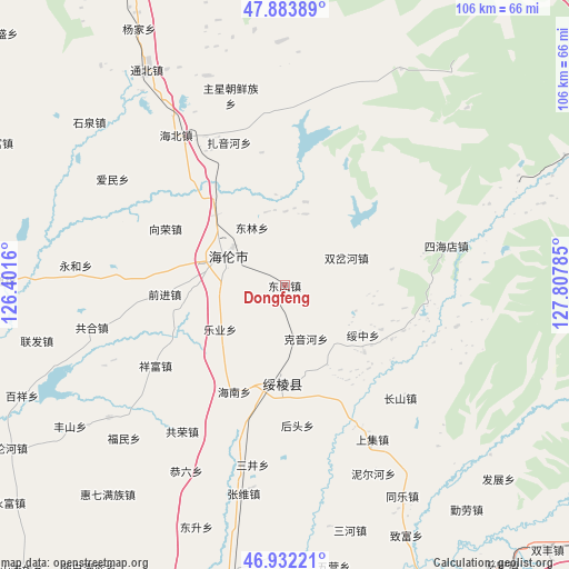
Dongfeng GPS coordinates[2]
47° 24' 36.72" North, 127° 6' 16.992" East
| Map corner | latitude | longitude |
|---|---|---|
| Upper-left | 47.88389°, | 126.4016° |
| Center: | 47.4102°, | 127.10472° |
| Lower-right: | 46.93221°, | 127.80785° |
| Map W x H: | 105.8×105.8 km | = 65.7×65.7mi |
| max Lat: | 53.31946° ⇑2.2% North |
| Dongfeng: | 47.4102° |
| min Lat: | ⇓97.8% South 18.22056° |
| min Long | Dongfeng | max Long |
| 75.07348° | 127.10472° | 134.28917° |
| W 96.9%⇐ | ⇒3.1% E |
Elevation
Elevation of Dongfeng is 255 m = 837 ft, and this is 229.8 m = 754 ft below average elevation for this country.
| Max E: |
5622 m = 18445 ft | 40.4% |
| Avg. | 484.8 m = 1591 ft | |
| Dongfeng | 255 m = 837 ft | |
Min E: |
-3 m = -10 ft | 59.6% |
See also: China elevation on elevation.city.
Geographical zone
Dongfeng is located in North temperate zone (between Tropic of Cancer and the Arctic Circle). Distance of this North polar circle is 2129.7 km =1323.3 mi to North.| Distance of | km | miles | from Dongfeng |
|---|---|---|---|
| North Pole | 4735.5 | 2942.5 | to North |
| Arctic Circle | 2129.7 | 1323.3 | to North |
| Tropic Cancer | 2665.6 | 1656.3 | to South |
| Equator | 5271.5 | 3275.6 | to South |


Nearby cities:
15 places around Dongfeng: (largest is in red/bold)
• Changfa
18.3 km =11.4 mi,  315°
315°
• Donglin
12.3 km =7.6 mi,  328°
328°
• Geshan
19.4 km =12.1 mi,  130°
130°
• Hailun
12.5 km =7.8 mi,  294°
294°
• Hainan
21.9 km =13.6 mi,  205°
205°
• Houtou
26.3 km =16.3 mi,  174°
174°
• Kaoshan
20.8 km =12.9 mi, 173°
• Keyinhe
11.1 km =6.9 mi,  154°
154°
• Leye
17.7 km =11 mi,  222°
222°
• Qianjin
22.1 km =13.7 mi,  266°
266°
• Shuangchahe
12.9 km =8 mi,  66°
66°
• Shuanglu
25 km =15.5 mi,  350°
350°
• Suileng
18 km =11.2 mi,  182°
182°
• Suizhong
17.4 km =10.8 mi,  121°
121°
• Xiangrong
24.6 km =15.3 mi,  297°
297°
Sources, notices
• [Note1] Compared only with cities in China existing in our database
• [Src1] Map data: © OpenStreetMap contributors (CC-BY-SA)
• [Src2] Other city data from geonames.org with taken over terms of usage.
• [Src3] Geographical zone / Annual Mean Temperature by Robert A. Rohde @ Wikipedia
