Chaba geodata
Chaba (Tibet) is a seat of a fourth-order administrative division; located in China in Asia/Shanghai (GMT+8) time zone. In our database, there are 1268 cities with bigger population. Compared to other cities in China, 63.4% of cities are located further ↑North; 97.2% of cities are located further →East and 98.6% of cities have lower elevation than Chaba. Note1


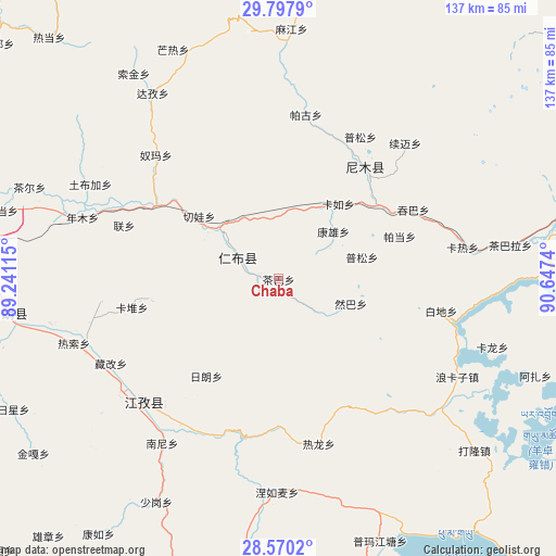
Chaba GPS coordinates[2]
29° 11' 9.204" North, 89° 56' 39.372" East
| Map corner | latitude | longitude |
|---|---|---|
| Upper-left | 29.7979°, | 89.24115° |
| Center: | 29.18589°, | 89.94427° |
| Lower-right: | 28.5702°, | 90.6474° |
| Map W x H: | 136.5×136.5 km | = 84.8×84.8mi |
| max Lat: | 53.31946° ⇑63.4% North |
| Chaba: | 29.18589° |
| min Lat: | ⇓36.6% South 18.22056° |
| min Long | Chaba | max Long |
| 75.07348° | 89.94427° | 134.28917° |
| W 2.8%⇐ | ⇒97.2% E |
Elevation
Elevation of Chaba is 3997 m = 13114 ft, and this is 3512.2 m = 11523 ft above average elevation for this country.
| Max E: |
5622 m = 18445 ft | 1.4% |
| Chaba | 3997 m 13114 ft | |
| Avg. | 484.8 m = 1591 ft | |
Min E: |
-3 m = -10 ft | 98.6% |
See also: China elevation on elevation.city.
Geographical zone
Chaba is located in North temperate zone (between Tropic of Cancer and the Arctic Circle). Distance of this Northern Tropic circle is 639.2 km =397.2 mi to South.| Distance of | km | miles | from Chaba |
|---|---|---|---|
| North Pole | 6761.9 | 4201.6 | to North |
| Arctic Circle | 4156 | 2582.4 | to North |
| Tropic Cancer | 639.2 | 397.2 | to South |
| Equator | 3245.2 | 2016.5 | to South |


Nearby cities:
15 places around Chaba: (largest is in red/bold)
• Dejilin
7.4 km =4.6 mi,  278°
278°
• Kangxung
17.7 km =11 mi,  49°
49°
• Kardoi
36.6 km =22.7 mi,  259°
259°
• Karru
23.5 km =14.6 mi,  38°
38°
• Lian
40.2 km =25 mi,  289°
289°
• Lungmar
36.4 km =22.6 mi,  180°
180°
• Mu
20.7 km =12.9 mi,  302°
302°
• Narong
32.1 km =19.9 mi, 261°
• Partang
31.7 km =19.7 mi,  69°
69°
• Pusum
40.1 km =24.9 mi,  29°
29°
• Qiangqinxue
10 km =6.2 mi,  334°
334°
• Qiewa
25.2 km =15.7 mi,  308°
308°
• Ralung
41.6 km =25.8 mi,  166°
166°
• Ramba
18.8 km =11.7 mi,  108°
108°
• Rinbung
15.9 km =9.9 mi, 304°
Sources, notices
• [Note1] Compared only with cities in China existing in our database
• [Src1] Map data: © OpenStreetMap contributors (CC-BY-SA)
• [Src2] Other city data from geonames.org with taken over terms of usage.
• [Src3] Geographical zone / Annual Mean Temperature by Robert A. Rohde @ Wikipedia
