Ramba geodata
Ramba (Tibet) is a seat of a fourth-order administrative division; located in China in Asia/Shanghai (GMT+8) time zone. In our database, there are 1268 cities with bigger population. Compared to other cities in China, 64% of cities are located further ↑North; 97.1% of cities are located further →East and 99.1% of cities have lower elevation than Ramba. Note1


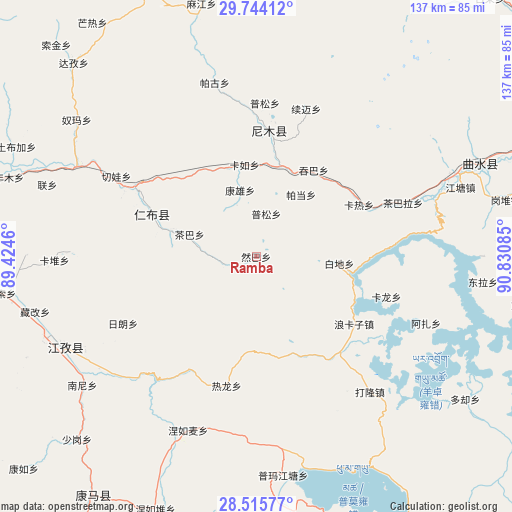
Ramba GPS coordinates[2]
29° 7' 54.408" North, 90° 7' 39.792" East
| Map corner | latitude | longitude |
|---|---|---|
| Upper-left | 29.74412°, | 89.4246° |
| Center: | 29.13178°, | 90.12772° |
| Lower-right: | 28.51577°, | 90.83085° |
| Map W x H: | 136.6×136.6 km | = 84.9×84.9mi |
| max Lat: | 53.31946° ⇑64% North |
| Ramba: | 29.13178° |
| min Lat: | ⇓36% South 18.22056° |
| min Long | Ramba | max Long |
| 75.07348° | 90.12772° | 134.28917° |
| W 2.9%⇐ | ⇒97.1% E |
Elevation
Elevation of Ramba is 4228 m = 13871 ft, and this is 3743.2 m = 12281 ft above average elevation for this country.
| Max E: |
5622 m = 18445 ft | 0.90000000000001% |
| Ramba | 4228 m 13871 ft | |
| Avg. | 484.8 m = 1591 ft | |
Min E: |
-3 m = -10 ft | 99.1% |
See also: China elevation on elevation.city.
Geographical zone
Ramba is located in North temperate zone (between Tropic of Cancer and the Arctic Circle). Distance of this Northern Tropic circle is 633.2 km =393.5 mi to South.| Distance of | km | miles | from Ramba |
|---|---|---|---|
| North Pole | 6767.9 | 4205.4 | to North |
| Arctic Circle | 4162 | 2586.1 | to North |
| Tropic Cancer | 633.2 | 393.5 | to South |
| Equator | 3239.2 | 2012.7 | to South |


Nearby cities:
15 places around Ramba: (largest is in red/bold)
• Chaba
18.8 km =11.7 mi,  288°
288°
• Dejilin
26.2 km =16.3 mi, 285°
• Kangxung
18.2 km =11.3 mi,  346°
346°
• Karlung
36.4 km =22.6 mi,  107°
107°
• Karru
24.7 km =15.3 mi, 352°
• Lungmar
35.5 km =22.1 mi,  210°
210°
• Mu
39.2 km =24.4 mi,  296°
296°
• Narong
49.6 km =30.8 mi,  271°
271°
• Partang
20.8 km =12.9 mi,  35°
35°
• Pusum
40.9 km =25.4 mi,  3°
3°
• Qiangqinxue
26.7 km =16.6 mi, 304°
• Qiewa
43.3 km =26.9 mi, 299°
• Ralung
35.3 km =21.9 mi,  192°
192°
• Rinbung
34.4 km =21.4 mi, 295°
• Xumai
39.8 km =24.7 mi,  19°
19°
Sources, notices
• [Note1] Compared only with cities in China existing in our database
• [Src1] Map data: © OpenStreetMap contributors (CC-BY-SA)
• [Src2] Other city data from geonames.org with taken over terms of usage.
• [Src3] Geographical zone / Annual Mean Temperature by Robert A. Rohde @ Wikipedia
