Partang geodata
Partang (Tibet) is a seat of a fourth-order administrative division; located in China in Asia/Shanghai (GMT+8) time zone. In our database, there are 1268 cities with bigger population. Compared to other cities in China, 62.2% of cities are located further ↑North; 97.1% of cities are located further →East and 98.8% of cities have lower elevation than Partang. Note1


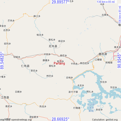
Partang GPS coordinates[2]
29° 17' 3.66" North, 90° 15' 4.932" East
| Map corner | latitude | longitude |
|---|---|---|
| Upper-left | 29.89577°, | 89.54825° |
| Center: | 29.28435°, | 90.25137° |
| Lower-right: | 28.66925°, | 90.9545° |
| Map W x H: | 136.4×136.4 km | = 84.8×84.8mi |
| max Lat: | 53.31946° ⇑62.2% North |
| Partang: | 29.28435° |
| min Lat: | ⇓37.8% South 18.22056° |
| min Long | Partang | max Long |
| 75.07348° | 90.25137° | 134.28917° |
| W 2.9%⇐ | ⇒97.1% E |
Elevation
Elevation of Partang is 4072 m = 13360 ft, and this is 3587.2 m = 11769 ft above average elevation for this country.
| Max E: |
5622 m = 18445 ft | 1.2% |
| Partang | 4072 m 13360 ft | |
| Avg. | 484.8 m = 1591 ft | |
Min E: |
-3 m = -10 ft | 98.8% |
See also: China elevation on elevation.city.
Geographical zone
Partang is located in North temperate zone (between Tropic of Cancer and the Arctic Circle). Distance of this Northern Tropic circle is 650.2 km =404 mi to South.| Distance of | km | miles | from Partang |
|---|---|---|---|
| North Pole | 6750.9 | 4194.8 | to North |
| Arctic Circle | 4145.1 | 2575.6 | to North |
| Tropic Cancer | 650.2 | 404 | to South |
| Equator | 3256.1 | 2023.2 | to South |


Nearby cities:
15 places around Partang: (largest is in red/bold)
• Chaba
31.7 km =19.7 mi,  249°
249°
• Dagar
42.1 km =26.2 mi,  81°
81°
• Dejilin
38.4 km =23.9 mi,  255°
255°
• Dongla
53.4 km =33.2 mi,  115°
115°
• Kangxung
16.4 km =10.2 mi,  272°
272°
• Karlung
35.8 km =22.2 mi,  140°
140°
• Karru
17 km =10.6 mi,  296°
296°
• Mu
47.1 km =29.3 mi, 270°
• Pusum
25.8 km =16 mi,  337°
337°
• Qiangqinxue
34.1 km =21.2 mi, 266°
• Qiewa
49.7 km =30.9 mi,  275°
275°
• Ralung
55.1 km =34.2 mi,  201°
201°
• Ramba
20.8 km =12.9 mi,  215°
215°
• Rinbung
42.9 km =26.7 mi, 267°
• Xumai
20.6 km =12.8 mi,  3°
3°
Sources, notices
• [Note1] Compared only with cities in China existing in our database
• [Src1] Map data: © OpenStreetMap contributors (CC-BY-SA)
• [Src2] Other city data from geonames.org with taken over terms of usage.
• [Src3] Geographical zone / Annual Mean Temperature by Robert A. Rohde @ Wikipedia
