Luojiang geodata
Luojiang (Tibet) is a seat of a fourth-order administrative division; located in China in Asia/Shanghai (GMT+8) time zone. In our database, there are 1268 cities with bigger population. Compared to other cities in China, 64.3% of cities are located further ↑North; 97.5% of cities are located further →East and 98.4% of cities have lower elevation than Luojiang. Note1


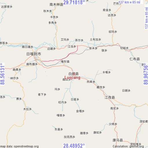
Luojiang GPS coordinates[2]
29° 6' 20.448" North, 89° 15' 51.948" East
| Map corner | latitude | longitude |
|---|---|---|
| Upper-left | 29.71818°, | 88.56131° |
| Center: | 29.10568°, | 89.26443° |
| Lower-right: | 28.48952°, | 89.96756° |
| Map W x H: | 136.6×136.6 km | = 84.9×84.9mi |
| max Lat: | 53.31946° ⇑64.3% North |
| Luojiang: | 29.10568° |
| min Lat: | ⇓35.7% South 18.22056° |
| min Long | Luojiang | max Long |
| 75.07348° | 89.26443° | 134.28917° |
| W 2.5%⇐ | ⇒97.5% E |
Elevation
Elevation of Luojiang is 3898 m = 12789 ft, and this is 3413.2 m = 11198 ft above average elevation for this country.
| Max E: |
5622 m = 18445 ft | 1.6% |
| Luojiang | 3898 m 12789 ft | |
| Avg. | 484.8 m = 1591 ft | |
Min E: |
-3 m = -10 ft | 98.4% |
See also: China elevation on elevation.city.
Geographical zone
Luojiang is located in North temperate zone (between Tropic of Cancer and the Arctic Circle). Distance of this Northern Tropic circle is 630.3 km =391.7 mi to South.| Distance of | km | miles | from Luojiang |
|---|---|---|---|
| North Pole | 6770.8 | 4207.2 | to North |
| Arctic Circle | 4164.9 | 2587.9 | to North |
| Tropic Cancer | 630.3 | 391.7 | to South |
| Equator | 3236.2 | 2010.9 | to South |


Nearby cities:
15 places around Luojiang: (largest is in red/bold)
• Bazha
14.9 km =9.3 mi,  306°
306°
• Dazi
17.3 km =10.7 mi,  103°
103°
• Duqiong
8.1 km =5 mi,  191°
191°
• Gadong
14.5 km =9 mi,  324°
324°
• Jangdam
25.9 km =16.1 mi,  356°
356°
• Karmai
22.7 km =14.1 mi,  81°
81°
• Luobuqiongzi
6.9 km =4.3 mi,  348°
348°
• Ma Xiang
20.4 km =12.7 mi,  229°
229°
• Nianmu
29.8 km =18.5 mi,  36°
36°
• Qiangdui
10 km =6.2 mi, 101°
• Rasog
17.2 km =10.7 mi,  111°
111°
• Rixing
22.7 km =14.1 mi,  177°
177°
• Wangdain
28.7 km =17.8 mi,  202°
202°
• Zangka
27.5 km =17.1 mi,  115°
115°
• Zhongzi
21.2 km =13.2 mi, 115°
Sources, notices
• [Note1] Compared only with cities in China existing in our database
• [Src1] Map data: © OpenStreetMap contributors (CC-BY-SA)
• [Src2] Other city data from geonames.org with taken over terms of usage.
• [Src3] Geographical zone / Annual Mean Temperature by Robert A. Rohde @ Wikipedia
