Dazi geodata
Dazi (Tibet) is a seat of a fourth-order administrative division; located in China in Asia/Shanghai (GMT+8) time zone. In our database, there are 1268 cities with bigger population. Compared to other cities in China, 64.6% of cities are located further ↑North; 97.5% of cities are located further →East and 98.5% of cities have lower elevation than Dazi. Note1


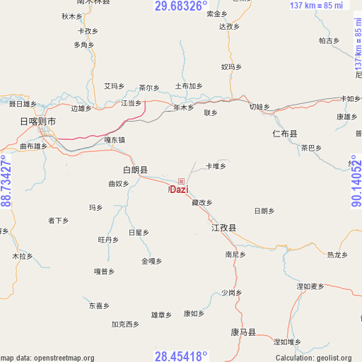
Dazi GPS coordinates[2]
29° 4' 13.98" North, 89° 26' 14.604" East
| Map corner | latitude | longitude |
|---|---|---|
| Upper-left | 29.68326°, | 88.73427° |
| Center: | 29.07055°, | 89.43739° |
| Lower-right: | 28.45418°, | 90.14052° |
| Map W x H: | 136.7×136.7 km | = 84.9×84.9mi |
| max Lat: | 53.31946° ⇑64.6% North |
| Dazi: | 29.07055° |
| min Lat: | ⇓35.4% South 18.22056° |
| min Long | Dazi | max Long |
| 75.07348° | 89.43739° | 134.28917° |
| W 2.5%⇐ | ⇒97.5% E |
Elevation
Elevation of Dazi is 3941 m = 12930 ft, and this is 3456.2 m = 11339 ft above average elevation for this country.
| Max E: |
5622 m = 18445 ft | 1.5% |
| Dazi | 3941 m 12930 ft | |
| Avg. | 484.8 m = 1591 ft | |
Min E: |
-3 m = -10 ft | 98.5% |
See also: China elevation on elevation.city.
Geographical zone
Dazi is located in North temperate zone (between Tropic of Cancer and the Arctic Circle). Distance of this Northern Tropic circle is 626.4 km =389.2 mi to South.| Distance of | km | miles | from Dazi |
|---|---|---|---|
| North Pole | 6774.7 | 4209.6 | to North |
| Arctic Circle | 4168.8 | 2590.4 | to North |
| Tropic Cancer | 626.4 | 389.2 | to South |
| Equator | 3232.3 | 2008.5 | to South |


Nearby cities:
15 places around Dazi: (largest is in red/bold)
• Duqiong
18.8 km =11.7 mi,  257°
257°
• Jangra
22.8 km =14.2 mi,  144°
144°
• Jiangzi
23 km =14.3 mi, 136°
• Kangzhuo
21 km =13 mi,  164°
164°
• Kardoi
14.5 km =9 mi,  66°
66°
• Karmai
9.1 km =5.7 mi,  38°
38°
• Luobuqiongzi
21.1 km =13.1 mi,  300°
300°
• Luojiang
17.3 km =10.7 mi,  283°
283°
• Narong
19.2 km =11.9 mi, 65°
• Qiangdui
7.2 km =4.5 mi,  285°
285°
• Rasog
2.6 km =1.6 mi,  199°
199°
• Rixing
24.5 km =15.2 mi,  220°
220°
• Zangka
11.3 km =7 mi,  134°
134°
• Zhongzi
5.8 km =3.6 mi, 157°
• Zijin
19.2 km =11.9 mi,  150°
150°
Sources, notices
• [Note1] Compared only with cities in China existing in our database
• [Src1] Map data: © OpenStreetMap contributors (CC-BY-SA)
• [Src2] Other city data from geonames.org with taken over terms of usage.
• [Src3] Geographical zone / Annual Mean Temperature by Robert A. Rohde @ Wikipedia
