Ercheng geodata
Ercheng (Hubei) is a seat of a fourth-order administrative division; located in China in Asia/Shanghai (GMT+8) time zone. In our database, there are 1268 cities with bigger population. Compared to other cities in China, 56.9% of cities are located further ↓South; 51.6% of cities are located further ←West and 60.6% of cities have higher elevation than Ercheng. Note1


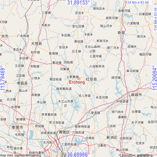
Ercheng GPS coordinates[2]
31° 17' 33.396" North, 114° 29' 52.116" East
| Map corner | latitude | longitude |
|---|---|---|
| Upper-left | 31.89153°, | 113.79469° |
| Center: | 31.29261°, | 114.49781° |
| Lower-right: | 30.68986°, | 115.20094° |
| Map W x H: | 133.6×133.6 km | = 83×83mi |
| max Lat: | 53.31946° ⇑43.1% North |
| Ercheng: | 31.29261° |
| min Lat: | ⇓56.9% South 18.22056° |
| min Long | Ercheng | max Long |
| 75.07348° | 114.49781° | 134.28917° |
| W 51.6%⇐ | ⇒48.4% E |
Elevation
Elevation of Ercheng is 95 m = 312 ft, and this is 389.8 m = 1279 ft below average elevation for this country.
| Max E: |
5622 m = 18445 ft | 60.6% |
| Avg. | 484.8 m = 1591 ft | |
| Ercheng | 95 m = 312 ft | |
Min E: |
-3 m = -10 ft | 39.4% |
See also: China elevation on elevation.city.
Geographical zone
Ercheng is located in North temperate zone (between Tropic of Cancer and the Arctic Circle). Distance of this Northern Tropic circle is 873.5 km =542.8 mi to South.| Distance of | km | miles | from Ercheng |
|---|---|---|---|
| North Pole | 6527.6 | 4056.1 | to North |
| Arctic Circle | 3921.8 | 2436.9 | to North |
| Tropic Cancer | 873.5 | 542.8 | to South |
| Equator | 3479.4 | 2162 | to South |


Nearby cities:
15 places around Ercheng: (largest is in red/bold)
• Caidian
19.6 km =12.2 mi,  270°
270°
• Gaoqiao
11.8 km =7.3 mi,  147°
147°
• Hekou
6.8 km =4.2 mi,  294°
294°
• Hong’an Chengguanzhen
15.3 km =9.5 mi,  59°
59°
• Huajiahe
19.1 km =11.9 mi,  9°
9°
• Liuji
14.8 km =9.2 mi,  304°
304°
• Luwang
23.8 km =14.8 mi,  354°
354°
• Mulan
21.9 km =13.6 mi,  190°
190°
• Qiliping
24 km =14.9 mi,  36°
36°
• Shangxinji
6.1 km =3.8 mi, 291°
• Sigu
16.6 km =10.3 mi,  326°
326°
• Xiadian
23.8 km =14.8 mi,  305°
305°
• Xinghua
12.1 km =7.5 mi,  96°
96°
• Yaojiaji
15.3 km =9.5 mi,  234°
234°
• Yongjiahe
25.2 km =15.7 mi,  127°
127°
Sources, notices
• [Note1] Compared only with cities in China existing in our database
• [Src1] Map data: © OpenStreetMap contributors (CC-BY-SA)
• [Src2] Other city data from geonames.org with taken over terms of usage.
• [Src3] Geographical zone / Annual Mean Temperature by Robert A. Rohde @ Wikipedia
