Huajiahe geodata
Huajiahe (Hubei) is a seat of a fourth-order administrative division; located in China in Asia/Shanghai (GMT+8) time zone. In our database, there are 1268 cities with bigger population. Compared to other cities in China, 58.1% of cities are located further ↓South; 51.7% of cities are located further ←West and 64.1% of cities have higher elevation than Huajiahe. Note1


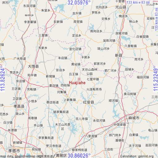
Huajiahe GPS coordinates[2]
31° 27' 42.948" North, 114° 31' 45.696" East
| Map corner | latitude | longitude |
|---|---|---|
| Upper-left | 32.05976°, | 113.82624° |
| Center: | 31.46193°, | 114.52936° |
| Lower-right: | 30.86026°, | 115.23249° |
| Map W x H: | 133.4×133.4 km | = 82.9×82.9mi |
| max Lat: | 53.31946° ⇑41.9% North |
| Huajiahe: | 31.46193° |
| min Lat: | ⇓58.1% South 18.22056° |
| min Long | Huajiahe | max Long |
| 75.07348° | 114.52936° | 134.28917° |
| W 51.7%⇐ | ⇒48.3% E |
Elevation
Elevation of Huajiahe is 77 m = 253 ft, and this is 407.8 m = 1338 ft below average elevation for this country.
| Max E: |
5622 m = 18445 ft | 64.1% |
| Avg. | 484.8 m = 1591 ft | |
| Huajiahe | 77 m = 253 ft | |
Min E: |
-3 m = -10 ft | 35.9% |
See also: China elevation on elevation.city.
Geographical zone
Huajiahe is located in North temperate zone (between Tropic of Cancer and the Arctic Circle). Distance of this Northern Tropic circle is 892.3 km =554.4 mi to South.| Distance of | km | miles | from Huajiahe |
|---|---|---|---|
| North Pole | 6508.8 | 4044.4 | to North |
| Arctic Circle | 3902.9 | 2425.1 | to North |
| Tropic Cancer | 892.3 | 554.4 | to South |
| Equator | 3498.2 | 2173.7 | to South |


Nearby cities:
15 places around Huajiahe: (largest is in red/bold)
• Ercheng
19.1 km =11.9 mi,  189°
189°
• Fengdian
22.9 km =14.2 mi,  321°
321°
• Hekou
18.5 km =11.5 mi,  209°
209°
• Hong’an Chengguanzhen
15.1 km =9.4 mi,  137°
137°
• Huangzhan
13.4 km =8.3 mi,  347°
347°
• Liuji
18.3 km =11.4 mi,  235°
235°
• Luwang
7.1 km =4.4 mi,  313°
313°
• Pengdian
17.7 km =11 mi,  297°
297°
• Qiliping
11.4 km =7.1 mi,  88°
88°
• Shangxinji
18.7 km =11.6 mi, 207°
• Sigu
13 km =8.1 mi,  247°
247°
• Xiadian
22.9 km =14.2 mi,  257°
257°
• Xincheng
25.2 km =15.7 mi,  276°
276°
• Xinghua
22.1 km =13.7 mi,  155°
155°
• Xuanhuadian
26.3 km =16.3 mi, 352°
Sources, notices
• [Note1] Compared only with cities in China existing in our database
• [Src1] Map data: © OpenStreetMap contributors (CC-BY-SA)
• [Src2] Other city data from geonames.org with taken over terms of usage.
• [Src3] Geographical zone / Annual Mean Temperature by Robert A. Rohde @ Wikipedia
