Xinghua geodata
Xinghua (Hubei) is a seat of a fourth-order administrative division; located in China in Asia/Shanghai (GMT+8) time zone. In our database, there are 1268 cities with bigger population. Compared to other cities in China, 56.8% of cities are located further ↓South; 52.2% of cities are located further ←West and 66.1% of cities have higher elevation than Xinghua. Note1


Xinghua GPS coordinates[2]
31° 16' 51.06" North, 114° 37' 28.704" East
| Map corner | latitude | longitude |
|---|---|---|
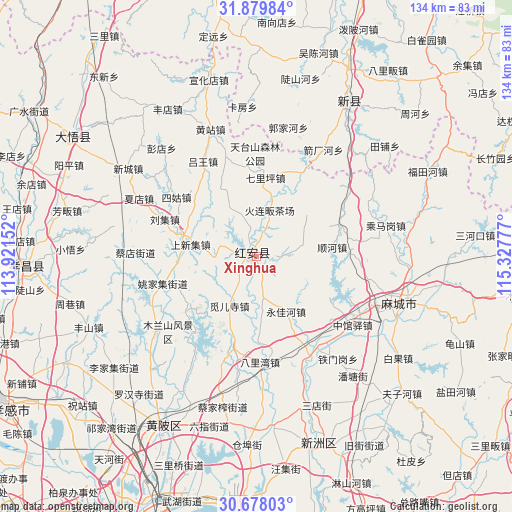
| Upper-left | 31.87984°, | 113.92152° |
| Center: | 31.28085°, | 114.62464° |
| Lower-right: | 30.67803°, | 115.32777° |
| Map W x H: | 133.6×133.6 km | = 83×83mi |
| max Lat: | 53.31946° ⇑43.2% North |
| Xinghua: | 31.28085° |
| min Lat: | ⇓56.8% South 18.22056° |
| min Long | Xinghua | max Long |
| 75.07348° | 114.62464° | 134.28917° |
| W 52.2%⇐ | ⇒47.8% E |
Elevation
Elevation of Xinghua is 68 m = 223 ft, and this is 416.8 m = 1367 ft below average elevation for this country.
| Max E: |
5622 m = 18445 ft | 66.1% |
| Avg. | 484.8 m = 1591 ft | |
| Xinghua | 68 m = 223 ft | |
Min E: |
-3 m = -10 ft | 33.9% |
See also: China elevation on elevation.city.
Geographical zone
Xinghua is located in North temperate zone (between Tropic of Cancer and the Arctic Circle). Distance of this Northern Tropic circle is 872.2 km =542 mi to South.| Distance of | km | miles | from Xinghua |
|---|---|---|---|
| North Pole | 6529 | 4056.9 | to North |
| Arctic Circle | 3923.1 | 2437.7 | to North |
| Tropic Cancer | 872.2 | 542 | to South |
| Equator | 3478.1 | 2161.2 | to South |


Nearby cities:
15 places around Xinghua: (largest is in red/bold)
• Ercheng
12.1 km =7.5 mi,  276°
276°
• Gaoqiao
10.4 km =6.5 mi,  213°
213°
• Hekou
18.7 km =11.6 mi, 282°
• Hong’an Chengguanzhen
9.1 km =5.7 mi,  7°
7°
• Huajiahe
22.1 km =13.7 mi,  335°
335°
• Liuji
26.1 km =16.2 mi,  291°
291°
• Mi’ersi
28.4 km =17.6 mi,  197°
197°
• Mulan
25.8 km =16 mi,  218°
218°
• Qiliping
20.6 km =12.8 mi, 6°
• Shangxinji
18 km =11.2 mi, 281°
• Shunhe
19.4 km =12.1 mi,  82°
82°
• Sigu
26 km =16.2 mi,  305°
305°
• Xiyang
24.3 km =15.1 mi,  112°
112°
• Yaojiaji
25.7 km =16 mi,  252°
252°
• Yongjiahe
16.1 km =10 mi,  150°
150°
Sources, notices
• [Note1] Compared only with cities in China existing in our database
• [Src1] Map data: © OpenStreetMap contributors (CC-BY-SA)
• [Src2] Other city data from geonames.org with taken over terms of usage.
• [Src3] Geographical zone / Annual Mean Temperature by Robert A. Rohde @ Wikipedia
