Xinglongchang geodata
Xinglongchang (Yunnan) is a seat of a fourth-order administrative division; located in China in Asia/Shanghai (GMT+8) time zone. In our database, there are 1268 cities with bigger population. Compared to other cities in China, 71.7% of cities are located further ↑North; 89.8% of cities are located further →East and 80.7% of cities have lower elevation than Xinglongchang. Note1


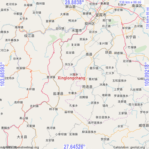
Xinglongchang GPS coordinates[2]
28° 15' 58.788" North, 104° 23' 20.58" East
| Map corner | latitude | longitude |
|---|---|---|
| Upper-left | 28.8838°, | 103.68593° |
| Center: | 28.26633°, | 104.38905° |
| Lower-right: | 27.64526°, | 105.09218° |
| Map W x H: | 137.7×137.7 km | = 85.6×85.6mi |
| max Lat: | 53.31946° ⇑71.7% North |
| Xinglongchang: | 28.26633° |
| min Lat: | ⇓28.3% South 18.22056° |
| min Long | Xinglongchang | max Long |
| 75.07348° | 104.38905° | 134.28917° |
| W 10.2%⇐ | ⇒89.8% E |
Elevation
Elevation of Xinglongchang is 726 m = 2382 ft, and this is 241.2 m = 791 ft above average elevation for this country.
| Max E: |
5622 m = 18445 ft | 19.3% |
| Xinglongchang | 726 m 2382 ft | |
| Avg. | 484.8 m = 1591 ft | |
Min E: |
-3 m = -10 ft | 80.7% |
See also: China elevation on elevation.city.
Geographical zone
Xinglongchang is located in North temperate zone (between Tropic of Cancer and the Arctic Circle). Distance of this Northern Tropic circle is 537 km =333.7 mi to South.| Distance of | km | miles | from Xinglongchang |
|---|---|---|---|
| North Pole | 6864.1 | 4265.2 | to North |
| Arctic Circle | 4258.3 | 2646 | to North |
| Tropic Cancer | 537 | 333.7 | to South |
| Equator | 3142.9 | 1952.9 | to South |


Nearby cities:
15 places around Xinglongchang: (largest is in red/bold)
• Aitianba
24.4 km =15.2 mi,  243°
243°
• Chuansiba
26.1 km =16.2 mi,  283°
283°
• Doushaguan
35.3 km =21.9 mi,  226°
226°
• Junlian
16 km =9.9 mi,  131°
131°
• Niupizhai
17.2 km =10.7 mi,  182°
182°
• Pu’er
21.9 km =13.6 mi,  265°
265°
• Qingfu
22.7 km =14.1 mi,  33°
33°
• Shiziba
37.9 km =23.5 mi,  212°
212°
• Taipingdian
36.4 km =22.6 mi,  333°
333°
• Tantou
12.1 km =7.5 mi, 278°
• Tantouchang
11.3 km =7 mi,  295°
295°
• Xishaqiao
39.8 km =24.7 mi, 275°
• Xunchang
38.1 km =23.7 mi,  56°
56°
• Yanjing
27.9 km =17.3 mi,  222°
222°
• Zhonghechang
31.1 km =19.3 mi,  246°
246°
Sources, notices
• [Note1] Compared only with cities in China existing in our database
• [Src1] Map data: © OpenStreetMap contributors (CC-BY-SA)
• [Src2] Other city data from geonames.org with taken over terms of usage.
• [Src3] Geographical zone / Annual Mean Temperature by Robert A. Rohde @ Wikipedia
