Qingfu geodata
Qingfu (Sichuan) is a seat of a third-order administrative division; located in China in Asia/Shanghai (GMT+8) time zone. In our database, there are 1268 cities with bigger population. Compared to other cities in China, 70.2% of cities are located further ↑North; 89.7% of cities are located further →East and 65.8% of cities have lower elevation than Qingfu. Note1


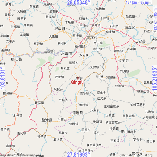
Qingfu GPS coordinates[2]
28° 26' 13.236" North, 104° 30' 58.392" East
| Map corner | latitude | longitude |
|---|---|---|
| Upper-left | 29.05348°, | 103.8131° |
| Center: | 28.43701°, | 104.51622° |
| Lower-right: | 27.81693°, | 105.21935° |
| Map W x H: | 137.5×137.5 km | = 85.4×85.4mi |
| max Lat: | 53.31946° ⇑70.2% North |
| Qingfu: | 28.43701° |
| min Lat: | ⇓29.8% South 18.22056° |
| min Long | Qingfu | max Long |
| 75.07348° | 104.51622° | 134.28917° |
| W 10.3%⇐ | ⇒89.7% E |
Elevation
Elevation of Qingfu is 339 m = 1112 ft, and this is 145.8 m = 478 ft below average elevation for this country.
| Max E: |
5622 m = 18445 ft | 34.2% |
| Avg. | 484.8 m = 1591 ft | |
| Qingfu | 339 m = 1112 ft | |
Min E: |
-3 m = -10 ft | 65.8% |
See also: China elevation on elevation.city.
Geographical zone
Qingfu is located in North temperate zone (between Tropic of Cancer and the Arctic Circle). Distance of this Northern Tropic circle is 556 km =345.5 mi to South.| Distance of | km | miles | from Qingfu |
|---|---|---|---|
| North Pole | 6845.2 | 4253.4 | to North |
| Arctic Circle | 4239.3 | 2634.2 | to North |
| Tropic Cancer | 556 | 345.5 | to South |
| Equator | 3161.9 | 1964.7 | to South |


Nearby cities:
15 places around Qingfu: (largest is in red/bold)
• Aitianba
45.5 km =28.3 mi,  228°
228°
• Baixi
29.4 km =18.3 mi,  6°
6°
• Changning
42.5 km =26.4 mi,  68°
68°
• Chuansiba
40 km =24.9 mi,  250°
250°
• Huiyi
35.4 km =22 mi,  304°
304°
• Junlian
29.6 km =18.4 mi,  180°
180°
• Niupizhai
38.5 km =23.9 mi,  200°
200°
• Pu’er
40 km =24.9 mi,  238°
238°
• Taipingdian
31.8 km =19.8 mi, 295°
• Tantou
29.8 km =18.5 mi, 235°
• Tantouchang
26.7 km =16.6 mi, 237°
• Xiangjiaba
24.4 km =15.2 mi,  333°
333°
• Xinglongchang
22.7 km =14.1 mi,  213°
213°
• Xunchang
19.5 km =12.1 mi,  84°
84°
• Yibin
38.1 km =23.7 mi,  15°
15°
Sources, notices
• [Note1] Compared only with cities in China existing in our database
• [Src1] Map data: © OpenStreetMap contributors (CC-BY-SA)
• [Src2] Other city data from geonames.org with taken over terms of usage.
• [Src3] Geographical zone / Annual Mean Temperature by Robert A. Rohde @ Wikipedia
