Beidaihe geodata
Beidaihe (Hebei) is a seat of a third-order administrative division; located in China in Asia/Shanghai (GMT+8) time zone. In our database, there are 1268 cities with bigger population. Compared to other cities in China, 85.8% of cities are located further ↓South; 78.7% of cities are located further ←West and 84.9% of cities have higher elevation than Beidaihe. Note1


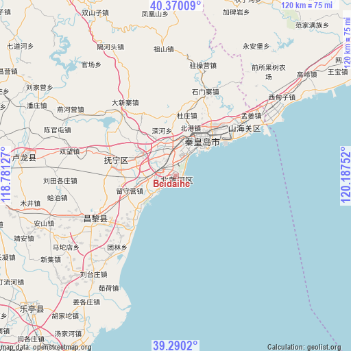
Beidaihe GPS coordinates[2]
39° 49' 56.172" North, 119° 29' 3.804" East
| Map corner | latitude | longitude |
|---|---|---|
| Upper-left | 40.37009°, | 118.78127° |
| Center: | 39.83227°, | 119.48439° |
| Lower-right: | 39.2902°, | 120.18752° |
| Map W x H: | 120.1×120.1 km | = 74.6×74.6mi |
| max Lat: | 53.31946° ⇑14.2% North |
| Beidaihe: | 39.83227° |
| min Lat: | ⇓85.8% South 18.22056° |
| min Long | Beidaihe | max Long |
| 75.07348° | 119.48439° | 134.28917° |
| W 78.7%⇐ | ⇒21.3% E |
Elevation
Elevation of Beidaihe is 16 m = 52 ft, and this is 468.8 m = 1538 ft below average elevation for this country.
| Max E: |
5622 m = 18445 ft | 84.9% |
| Avg. | 484.8 m = 1591 ft | |
| Beidaihe | 16 m = 52 ft | |
Min E: |
-3 m = -10 ft | 15.1% |
See also: China elevation on elevation.city.
Geographical zone
Beidaihe is located in North temperate zone (between Tropic of Cancer and the Arctic Circle). Distance of this Northern Tropic circle is 1823 km =1132.8 mi to South.| Distance of | km | miles | from Beidaihe |
|---|---|---|---|
| North Pole | 5578.1 | 3466.1 | to North |
| Arctic Circle | 2972.2 | 1846.8 | to North |
| Tropic Cancer | 1823 | 1132.8 | to South |
| Equator | 4428.9 | 2752 | to South |


Nearby cities:
15 places around Beidaihe: (largest is in red/bold)
• Beidaihehaibin
3.1 km =1.9 mi,  111°
111°
• Changli
31.9 km =19.8 mi,  243°
243°
• Dadianzi
52.2 km =32.4 mi,  31°
31°
• Dongshangen
65.2 km =40.5 mi,  22°
22°
• Gaoling
56.6 km =35.2 mi,  52°
52°
• Guta
65.8 km =40.9 mi, 52°
• Jiabeiyan
59.2 km =36.8 mi, 20°
• Lijiabao
41.2 km =25.6 mi,  41°
41°
• Luanzhou
64.8 km =40.3 mi,  261°
261°
• Qiansuo
49.1 km =30.5 mi, 53°
• Qinhuangdao
14.2 km =8.8 mi, 38°
• Shanhaiguan
29.4 km =18.3 mi, 49°
• Wangbao
65.7 km =40.8 mi,  56°
56°
• Wangjiazhuang
40.1 km =24.9 mi, 51°
• Xidianzi
47.9 km =29.8 mi, 53°
Sources, notices
• [Note1] Compared only with cities in China existing in our database
• [Src1] Map data: © OpenStreetMap contributors (CC-BY-SA)
• [Src2] Other city data from geonames.org with taken over terms of usage.
• [Src3] Geographical zone / Annual Mean Temperature by Robert A. Rohde @ Wikipedia
