Changli geodata
Changli (Hebei) is a populated place; located in China in Asia/Shanghai (GMT+8) time zone. With population of 64,476 people, there are 674 cities with bigger population in this country. Compared to other cities in China, 85.3% of cities are located further ↓South; 76.8% of cities are located further ←West and 82.9% of cities have higher elevation than Changli. Note1


Changli GPS coordinates[2]
39° 42' 15.012" North, 119° 9' 2.016" East
| Map corner | latitude | longitude |
|---|---|---|
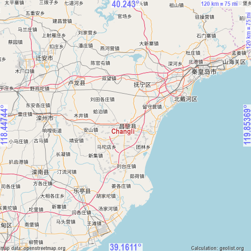
| Upper-left | 40.243°, | 118.44744° |
| Center: | 39.70417°, | 119.15056° |
| Lower-right: | 39.1611°, | 119.85369° |
| Map W x H: | 120.3×120.3 km | = 74.8×74.8mi |
| max Lat: | 53.31946° ⇑14.7% North |
| Changli: | 39.70417° |
| min Lat: | ⇓85.3% South 18.22056° |
| min Long | Changli | max Long |
| 75.07348° | 119.15056° | 134.28917° |
| W 76.8%⇐ | ⇒23.2% E |
Elevation
Elevation of Changli is 20 m = 66 ft, and this is 464.8 m = 1525 ft below average elevation for this country.
| Max E: |
5622 m = 18445 ft | 82.9% |
| Avg. | 484.8 m = 1591 ft | |
| Changli | 20 m = 66 ft | |
Min E: |
-3 m = -10 ft | 17.1% |
See also: Changli elevation on elevation.city.
Geographical zone
Changli is located in North temperate zone (between Tropic of Cancer and the Arctic Circle). Distance of this Northern Tropic circle is 1808.8 km =1123.9 mi to South.| Distance of | km | miles | from Changli |
|---|---|---|---|
| North Pole | 5592.4 | 3475 | to North |
| Arctic Circle | 2986.5 | 1855.7 | to North |
| Tropic Cancer | 1808.8 | 1123.9 | to South |
| Equator | 4414.7 | 2743.2 | to South |


Nearby cities:
15 places around Changli: (largest is in red/bold)
• Beidaihe
31.9 km =19.8 mi,  63°
63°
• Beidaihehaibin
34 km =21.1 mi,  67°
67°
• Bencheng
44.8 km =27.8 mi,  239°
239°
• Guye
60.8 km =37.8 mi,  272°
272°
• Kaiping
76.9 km =47.8 mi, 267°
• Lijiabao
71.7 km =44.6 mi,  51°
51°
• Linxi
60 km =37.3 mi, 270°
• Luanzhou
36 km =22.4 mi,  278°
278°
• Qinglong
79.9 km =49.6 mi,  347°
347°
• Qinhuangdao
45.1 km =28 mi, 55°
• Shanhaiguan
60.9 km =37.8 mi, 56°
• Tangjiazhuang
60 km =37.3 mi, 274°
• Wangjiazhuang
71.7 km =44.6 mi, 57°
• Xidianzi
79.4 km =49.3 mi, 57°
• Zhaogezhuang
63.5 km =39.5 mi, 276°
Sources, notices
• [Note1] Compared only with cities in China existing in our database
• [Src1] Map data: © OpenStreetMap contributors (CC-BY-SA)
• [Src2] Other city data from geonames.org with taken over terms of usage.
• [Src3] Geographical zone / Annual Mean Temperature by Robert A. Rohde @ Wikipedia
