Luocheng geodata
Luocheng (Gansu) is a seat of a fourth-order administrative division; located in China in Asia/Shanghai (GMT+8) time zone. In our database, there are 1268 cities with bigger population. Compared to other cities in China, 85.2% of cities are located further ↓South; 94.8% of cities are located further →East and 89.3% of cities have lower elevation than Luocheng. Note1


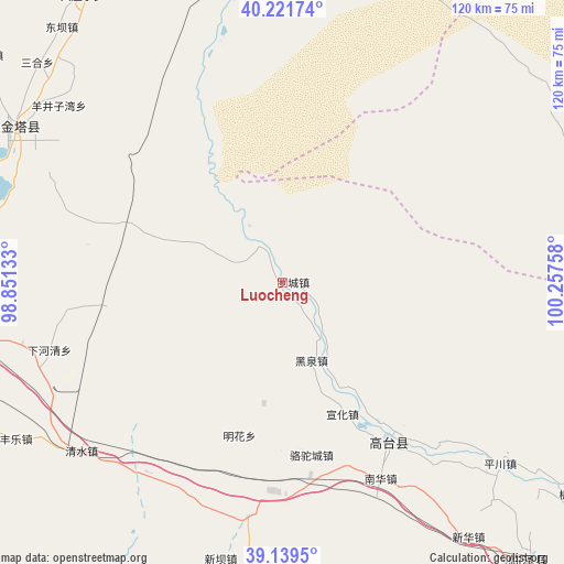
Luocheng GPS coordinates[2]
39° 40' 57.864" North, 99° 33' 16.02" East
| Map corner | latitude | longitude |
|---|---|---|
| Upper-left | 40.22174°, | 98.85133° |
| Center: | 39.68274°, | 99.55445° |
| Lower-right: | 39.1395°, | 100.25758° |
| Map W x H: | 120.3×120.3 km | = 74.8×74.8mi |
| max Lat: | 53.31946° ⇑14.8% North |
| Luocheng: | 39.68274° |
| min Lat: | ⇓85.2% South 18.22056° |
| min Long | Luocheng | max Long |
| 75.07348° | 99.55445° | 134.28917° |
| W 5.2%⇐ | ⇒94.8% E |
Elevation
Elevation of Luocheng is 1297 m = 4255 ft, and this is 812.2 m = 2665 ft above average elevation for this country.
| Max E: |
5622 m = 18445 ft | 10.7% |
| Luocheng | 1297 m 4255 ft | |
| Avg. | 484.8 m = 1591 ft | |
Min E: |
-3 m = -10 ft | 89.3% |
See also: China elevation on elevation.city.
Geographical zone
Luocheng is located in North temperate zone (between Tropic of Cancer and the Arctic Circle). Distance of this Northern Tropic circle is 1806.4 km =1122.4 mi to South.| Distance of | km | miles | from Luocheng |
|---|---|---|---|
| North Pole | 5594.8 | 3476.4 | to North |
| Arctic Circle | 2988.9 | 1857.2 | to North |
| Tropic Cancer | 1806.4 | 1122.4 | to South |
| Equator | 4412.3 | 2741.7 | to South |


Nearby cities:
15 places around Luocheng: (largest is in red/bold)
• Gaotai Chengguanzhen
43.1 km =26.8 mi,  150°
150°
• Heiquan
19.2 km =11.9 mi,  163°
163°
• Hongyazi
62.7 km =39 mi,  200°
200°
• Huangnibao
63 km =39.1 mi,  273°
273°
• Jiji
53.2 km =33.1 mi,  345°
345°
• Jinta
65.5 km =40.7 mi,  301°
301°
• Lianhua
39.3 km =24.4 mi,  261°
261°
• Liaoquan
55.3 km =34.4 mi,  132°
132°
• Minghai
23.5 km =14.6 mi,  210°
210°
• Nanhua
45.2 km =28.1 mi, 154°
• Qingshui
49.1 km =30.5 mi,  227°
227°
• Xiaheqing
52 km =32.3 mi, 255°
• Xinba
59.7 km =37.1 mi,  192°
192°
• Xinhua
65.9 km =40.9 mi,  144°
144°
• Yangjingziwan
60.8 km =37.8 mi,  308°
308°
Sources, notices
• [Note1] Compared only with cities in China existing in our database
• [Src1] Map data: © OpenStreetMap contributors (CC-BY-SA)
• [Src2] Other city data from geonames.org with taken over terms of usage.
• [Src3] Geographical zone / Annual Mean Temperature by Robert A. Rohde @ Wikipedia
