Namling geodata
Namling (Tibet) is a seat of a third-order administrative division; located in China in Asia/Shanghai (GMT+8) time zone. In our database, there are 1268 cities with bigger population. Compared to other cities in China, 57.6% of cities are located further ↑North; 97.7% of cities are located further →East and 98.7% of cities have lower elevation than Namling. Note1


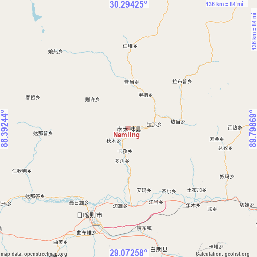
Namling GPS coordinates[2]
29° 41' 6.972" North, 89° 5' 44.016" East
| Map corner | latitude | longitude |
|---|---|---|
| Upper-left | 30.29425°, | 88.39244° |
| Center: | 29.68527°, | 89.09556° |
| Lower-right: | 29.07258°, | 89.79869° |
| Map W x H: | 135.8×135.8 km | = 84.4×84.4mi |
| max Lat: | 53.31946° ⇑57.6% North |
| Namling: | 29.68527° |
| min Lat: | ⇓42.4% South 18.22056° |
| min Long | Namling | max Long |
| 75.07348° | 89.09556° | 134.28917° |
| W 2.3%⇐ | ⇒97.7% E |
Elevation
Elevation of Namling is 4004 m = 13136 ft, and this is 3519.2 m = 11546 ft above average elevation for this country.
| Max E: |
5622 m = 18445 ft | 1.3% |
| Namling | 4004 m 13136 ft | |
| Avg. | 484.8 m = 1591 ft | |
Min E: |
-3 m = -10 ft | 98.7% |
See also: China elevation on elevation.city.
Geographical zone
Namling is located in North temperate zone (between Tropic of Cancer and the Arctic Circle). Distance of this Northern Tropic circle is 694.8 km =431.7 mi to South.| Distance of | km | miles | from Namling |
|---|---|---|---|
| North Pole | 6706.4 | 4167.2 | to North |
| Arctic Circle | 4100.5 | 2547.9 | to North |
| Tropic Cancer | 694.8 | 431.7 | to South |
| Equator | 3300.7 | 2051 | to South |


Nearby cities:
15 places around Namling: (largest is in red/bold)
• Bianxiong
40.9 km =25.4 mi,  186°
186°
• Car
39.1 km =24.3 mi,  147°
147°
• Dana
13.7 km =8.5 mi,  80°
80°
• Dazi
51.5 km =32 mi,  100°
100°
• Dobjoi
17.2 km =10.7 mi, 191°
• Gyamco
20 km =12.4 mi,  26°
26°
• Jangdam
41.3 km =25.7 mi,  159°
159°
• Kazi
11.8 km =7.3 mi, 189°
• Lhabupu
34.1 km =21.2 mi,  54°
54°
• Pundam
24.4 km =15.2 mi,  4°
4°
• Qum
9.5 km =5.9 mi,  233°
233°
• Ratang
26.6 km =16.5 mi, 82°
• Rendui
43.2 km =26.8 mi, 1°
• Renwu
12.5 km =7.8 mi,  224°
224°
• Suojin
45.3 km =28.1 mi, 96°
Sources, notices
• [Note1] Compared only with cities in China existing in our database
• [Src1] Map data: © OpenStreetMap contributors (CC-BY-SA)
• [Src2] Other city data from geonames.org with taken over terms of usage.
• [Src3] Geographical zone / Annual Mean Temperature by Robert A. Rohde @ Wikipedia
