Tekes geodata
Tekes (Xinjiang) is a seat of a third-order administrative division; located in China in Asia/Urumqi (GMT+6) time zone. In our database, there are 1268 cities with bigger population. Compared to other cities in China, 92.1% of cities are located further ↓South; 99.2% of cities are located further →East and 88.2% of cities have lower elevation than Tekes. Note1


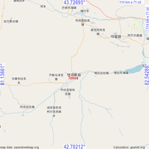
Tekes GPS coordinates[2]
43° 13' 0.084" North, 81° 50' 23.028" East
| Map corner | latitude | longitude |
|---|---|---|
| Upper-left | 43.72695°, | 81.13661° |
| Center: | 43.21669°, | 81.83973° |
| Lower-right: | 42.70212°, | 82.54286° |
| Map W x H: | 114×113.9 km | = 70.8×70.8mi |
| max Lat: | 53.31946° ⇑7.9% North |
| Tekes: | 43.21669° |
| min Lat: | ⇓92.1% South 18.22056° |
| min Long | Tekes | max Long |
| 75.07348° | 81.83973° | 134.28917° |
| W 0.8%⇐ | ⇒99.2% E |
Elevation
Elevation of Tekes is 1204 m = 3950 ft, and this is 719.2 m = 2360 ft above average elevation for this country.
| Max E: |
5622 m = 18445 ft | 11.8% |
| Tekes | 1204 m 3950 ft | |
| Avg. | 484.8 m = 1591 ft | |
Min E: |
-3 m = -10 ft | 88.2% |
See also: China elevation on elevation.city.
Geographical zone
Tekes is located in North temperate zone (between Tropic of Cancer and the Arctic Circle). Distance of this Northern Tropic circle is 2199.3 km =1366.6 mi to South.| Distance of | km | miles | from Tekes |
|---|---|---|---|
| North Pole | 5201.8 | 3232.2 | to North |
| Arctic Circle | 2595.9 | 1613 | to North |
| Tropic Cancer | 2199.3 | 1366.6 | to South |
| Equator | 4805.2 | 2985.8 | to South |


Nearby cities:
15 places around Tekes: (largest is in red/bold)
• Agarsin
54.9 km =34.1 mi,  56°
56°
• Akdala
45.1 km =28 mi,  235°
235°
• Dongmazar
68.4 km =42.5 mi,  0°
0°
• Hujirti
4.4 km =2.7 mi,  74°
74°
• Jagistay
64 km =39.8 mi,  308°
308°
• Kan
55.8 km =34.7 mi,  334°
334°
• Karasu
75.5 km =46.9 mi,  21°
21°
• Kax
47.3 km =29.4 mi, 2°
• Muhur
64.3 km =40 mi,  91°
91°
• Onyar
70.6 km =43.9 mi,  356°
356°
• Tikerik
37.9 km =23.5 mi,  28°
28°
• Tokkuztara
37.4 km =23.2 mi,  41°
41°
• Yengitam
60.7 km =37.7 mi,  345°
345°
• Yuqunweng
75.2 km =46.7 mi, 346°
• Zhaosu
62.8 km =39 mi,  260°
260°
Sources, notices
• [Note1] Compared only with cities in China existing in our database
• [Src1] Map data: © OpenStreetMap contributors (CC-BY-SA)
• [Src2] Other city data from geonames.org with taken over terms of usage.
• [Src3] Geographical zone / Annual Mean Temperature by Robert A. Rohde @ Wikipedia
