Hami geodata
Hami (Xinjiang) is a populated place; located in China in Asia/Urumqi (GMT+6) time zone. With population of 137,072 people, there are 322 cities with bigger population in this country. Compared to other cities in China, 91.7% of cities are located further ↓South; 96.5% of cities are located further →East and 81.4% of cities have lower elevation than Hami. Note1


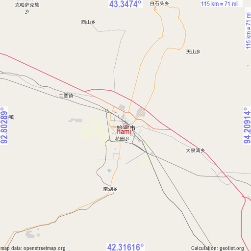
Hami GPS coordinates[2]
42° 50' 2.148" North, 93° 30' 21.636" East
| Map corner | latitude | longitude |
|---|---|---|
| Upper-left | 43.3474°, | 92.80289° |
| Center: | 42.83393°, | 93.50601° |
| Lower-right: | 42.31616°, | 94.20914° |
| Map W x H: | 114.7×114.7 km | = 71.3×71.3mi |
| max Lat: | 53.31946° ⇑8.3% North |
| Hami: | 42.83393° |
| min Lat: | ⇓91.7% South 18.22056° |
| min Long | Hami | max Long |
| 75.07348° | 93.50601° | 134.28917° |
| W 3.5%⇐ | ⇒96.5% E |
Elevation
Elevation of Hami is 762 m = 2500 ft, and this is 277.2 m = 909 ft above average elevation for this country.
| Max E: |
5622 m = 18445 ft | 18.6% |
| Hami | 762 m 2500 ft | |
| Avg. | 484.8 m = 1591 ft | |
Min E: |
-3 m = -10 ft | 81.4% |
See also: Hami elevation on elevation.city.
Geographical zone
Hami is located in North temperate zone (between Tropic of Cancer and the Arctic Circle). Distance of this Northern Tropic circle is 2156.8 km =1340.2 mi to South.| Distance of | km | miles | from Hami |
|---|---|---|---|
| North Pole | 5244.4 | 3258.7 | to North |
| Arctic Circle | 2638.5 | 1639.5 | to North |
| Tropic Cancer | 2156.8 | 1340.2 | to South |
| Equator | 4762.7 | 2959.4 | to South |


Nearby cities:
15 places around Hami: (largest is in red/bold)
• Barkol
94.1 km =58.5 mi,  334°
334°
• Guojiabao
311.5 km =193.6 mi,  160°
160°
• Huangqu
301.1 km =187.1 mi, 160°
• Liuyuan
253.5 km =157.5 mi,  139°
139°
• Lüjiabao
310.4 km =192.9 mi, 161°
• Mazongshan
311 km =193.2 mi,  111°
111°
• Mengjiaqiao
309.1 km =192.1 mi, 162°
• Mori
289.6 km =179.9 mi,  292°
292°
• Qoren
310.1 km =192.7 mi,  296°
296°
• Queren
307.9 km =191.3 mi, 297°
• Shanshan
269.1 km =167.2 mi,  270°
270°
• Suzhou
311.5 km =193.6 mi, 162°
• Xihu
283.4 km =176.1 mi,  154°
154°
• Yiwu
107 km =66.5 mi,  64°
64°
• Zhuanqukou
305.4 km =189.8 mi, 160°
Sources, notices
• [Note1] Compared only with cities in China existing in our database
• [Src1] Map data: © OpenStreetMap contributors (CC-BY-SA)
• [Src2] Other city data from geonames.org with taken over terms of usage.
• [Src3] Geographical zone / Annual Mean Temperature by Robert A. Rohde @ Wikipedia
