Heshi geodata
Heshi (Jiangsu) is a seat of a fourth-order administrative division; located in China in Asia/Shanghai (GMT+8) time zone. In our database, there are 1268 cities with bigger population. Compared to other cities in China, 62.5% of cities are located further ↓South; 82.8% of cities are located further ←West and 87.7% of cities have higher elevation than Heshi. Note1


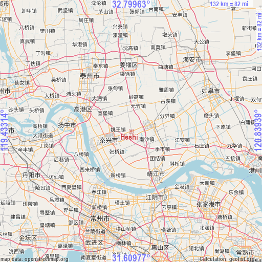
Heshi GPS coordinates[2]
32° 12' 23.94" North, 120° 8' 10.536" East
| Map corner | latitude | longitude |
|---|---|---|
| Upper-left | 32.79963°, | 119.43314° |
| Center: | 32.20665°, | 120.13626° |
| Lower-right: | 31.60977°, | 120.83939° |
| Map W x H: | 132.3×132.3 km | = 82.2×82.2mi |
| max Lat: | 53.31946° ⇑37.5% North |
| Heshi: | 32.20665° |
| min Lat: | ⇓62.5% South 18.22056° |
| min Long | Heshi | max Long |
| 75.07348° | 120.13626° | 134.28917° |
| W 82.8%⇐ | ⇒17.2% E |
Elevation
Elevation of Heshi is 12 m = 39 ft, and this is 472.8 m = 1551 ft below average elevation for this country.
| Max E: |
5622 m = 18445 ft | 87.7% |
| Avg. | 484.8 m = 1591 ft | |
| Heshi | 12 m = 39 ft | |
Min E: |
-3 m = -10 ft | 12.3% |
See also: China elevation on elevation.city.
Geographical zone
Heshi is located in North temperate zone (between Tropic of Cancer and the Arctic Circle). Distance of this Northern Tropic circle is 975.1 km =605.9 mi to South.| Distance of | km | miles | from Heshi |
|---|---|---|---|
| North Pole | 6426 | 3992.9 | to North |
| Arctic Circle | 3820.1 | 2373.7 | to North |
| Tropic Cancer | 975.1 | 605.9 | to South |
| Equator | 3581 | 2225.1 | to South |


Nearby cities:
15 places around Heshi: (largest is in red/bold)
• Dasheng
16.2 km =10.1 mi,  243°
243°
• Gensi
12.9 km =8 mi,  292°
292°
• Guangling
14.8 km =9.2 mi,  140°
140°
• Hongguang
16.2 km =10.1 mi,  190°
190°
• Huangqiao
9.8 km =6.1 mi,  67°
67°
• Liuchen
6.8 km =4.2 mi,  10°
10°
• Nansha
8.7 km =5.4 mi,  115°
115°
• Quxia
12 km =7.5 mi,  170°
170°
• Taixing
12.4 km =7.7 mi,  248°
248°
• Xinjie
14.7 km =9.1 mi,  350°
350°
• Xiqiao
4.8 km =3 mi,  63°
63°
• Xuanbao
16.5 km =10.3 mi,  304°
304°
• Yaowang
6.6 km =4.1 mi,  279°
279°
• Yuanzhu
13.6 km =8.5 mi,  15°
15°
• Zhangqiao
12.4 km =7.7 mi,  215°
215°
Sources, notices
• [Note1] Compared only with cities in China existing in our database
• [Src1] Map data: © OpenStreetMap contributors (CC-BY-SA)
• [Src2] Other city data from geonames.org with taken over terms of usage.
• [Src3] Geographical zone / Annual Mean Temperature by Robert A. Rohde @ Wikipedia
