Huangqiao geodata
Huangqiao (Jiangsu) is a seat of a fourth-order administrative division; located in China in Asia/Shanghai (GMT+8) time zone. In our database, there are 1268 cities with bigger population. Compared to other cities in China, 62.7% of cities are located further ↓South; 83.4% of cities are located further ←West and 89.9% of cities have higher elevation than Huangqiao. Note1


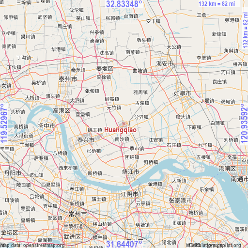
Huangqiao GPS coordinates[2]
32° 14' 26.592" North, 120° 13' 58.044" East
| Map corner | latitude | longitude |
|---|---|---|
| Upper-left | 32.83348°, | 119.52967° |
| Center: | 32.24072°, | 120.23279° |
| Lower-right: | 31.64407°, | 120.93592° |
| Map W x H: | 132.2×132.3 km | = 82.1×82.2mi |
| max Lat: | 53.31946° ⇑37.3% North |
| Huangqiao: | 32.24072° |
| min Lat: | ⇓62.7% South 18.22056° |
| min Long | Huangqiao | max Long |
| 75.07348° | 120.23279° | 134.28917° |
| W 83.4%⇐ | ⇒16.6% E |
Elevation
Elevation of Huangqiao is 10 m = 33 ft, and this is 474.8 m = 1558 ft below average elevation for this country.
| Max E: |
5622 m = 18445 ft | 89.9% |
| Avg. | 484.8 m = 1591 ft | |
| Huangqiao | 10 m = 33 ft | |
Min E: |
-3 m = -10 ft | 10.1% |
See also: China elevation on elevation.city.
Geographical zone
Huangqiao is located in North temperate zone (between Tropic of Cancer and the Arctic Circle). Distance of this Northern Tropic circle is 978.9 km =608.3 mi to South.| Distance of | km | miles | from Huangqiao |
|---|---|---|---|
| North Pole | 6422.2 | 3990.6 | to North |
| Arctic Circle | 3816.3 | 2371.3 | to North |
| Tropic Cancer | 978.9 | 608.3 | to South |
| Equator | 3584.8 | 2227.5 | to South |


Nearby cities:
15 places around Huangqiao: (largest is in red/bold)
• Fenjie
10 km =6.2 mi,  65°
65°
• Gaoming
13 km =8.1 mi,  85°
85°
• Guangling
15.2 km =9.4 mi,  178°
178°
• Gugao
15.2 km =9.4 mi,  334°
334°
• Guxi
15.1 km =9.4 mi,  39°
39°
• Hengduo
9.3 km =5.8 mi,  26°
26°
• Heshi
9.8 km =6.1 mi,  247°
247°
• Jiangduo
14 km =8.7 mi,  3°
3°
• Jishi
13.6 km =8.5 mi,  149°
149°
• Liuchen
8.3 km =5.2 mi,  290°
290°
• Nansha
7.6 km =4.7 mi,  189°
189°
• Shanhu
10.6 km =6.6 mi,  130°
130°
• Xinjie
15.7 km =9.8 mi,  312°
312°
• Xiqiao
5 km =3.1 mi, 250°
• Yuanzhu
10.8 km =6.7 mi, 329°
Sources, notices
• [Note1] Compared only with cities in China existing in our database
• [Src1] Map data: © OpenStreetMap contributors (CC-BY-SA)
• [Src2] Other city data from geonames.org with taken over terms of usage.
• [Src3] Geographical zone / Annual Mean Temperature by Robert A. Rohde @ Wikipedia
