Changbao geodata
Changbao (Guizhou) is a seat of a fourth-order administrative division; located in China in Asia/Shanghai (GMT+8) time zone. In our database, there are 1268 cities with bigger population. Compared to other cities in China, 72.5% of cities are located further ↑North; 79.5% of cities are located further →East and 66.9% of cities have lower elevation than Changbao. Note1


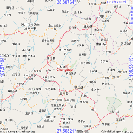
Changbao GPS coordinates[2]
28° 11' 22.992" North, 108° 16' 41.016" East
| Map corner | latitude | longitude |
|---|---|---|
| Upper-left | 28.80764°, | 107.57494° |
| Center: | 28.18972°, | 108.27806° |
| Lower-right: | 27.56821°, | 108.98119° |
| Map W x H: | 137.8×137.8 km | = 85.6×85.6mi |
| max Lat: | 53.31946° ⇑72.5% North |
| Changbao: | 28.18972° |
| min Lat: | ⇓27.5% South 18.22056° |
| min Long | Changbao | max Long |
| 75.07348° | 108.27806° | 134.28917° |
| W 20.5%⇐ | ⇒79.5% E |
Elevation
Elevation of Changbao is 357 m = 1171 ft, and this is 127.8 m = 419 ft below average elevation for this country.
| Max E: |
5622 m = 18445 ft | 33.1% |
| Avg. | 484.8 m = 1591 ft | |
| Changbao | 357 m = 1171 ft | |
Min E: |
-3 m = -10 ft | 66.9% |
See also: China elevation on elevation.city.
Geographical zone
Changbao is located in North temperate zone (between Tropic of Cancer and the Arctic Circle). Distance of this Northern Tropic circle is 528.5 km =328.4 mi to South.| Distance of | km | miles | from Changbao |
|---|---|---|---|
| North Pole | 6872.7 | 4270.5 | to North |
| Arctic Circle | 4266.8 | 2651.3 | to North |
| Tropic Cancer | 528.5 | 328.4 | to South |
| Equator | 3134.4 | 1947.6 | to South |


Nearby cities:
15 places around Changbao: (largest is in red/bold)
• Banxi
22.8 km =14.2 mi,  124°
124°
• Chaodi
10.7 km =6.6 mi,  204°
204°
• Donghua
22.3 km =13.9 mi,  236°
236°
• Fengxiangxi
8.2 km =5.1 mi,  146°
146°
• Gonghe
6.3 km =3.9 mi,  280°
280°
• Jiashi
16.8 km =10.4 mi,  18°
18°
• Jingjiao
21.8 km =13.5 mi,  334°
334°
• Qiaojia
20.8 km =12.9 mi,  52°
52°
• Qinglong
18.2 km =11.3 mi,  296°
296°
• Shanshu
15.7 km =9.8 mi, 123°
• Shazipo
19.7 km =12.2 mi,  78°
78°
• Tongjing
16.2 km =10.1 mi,  355°
355°
• Wenping
15 km =9.3 mi,  336°
336°
• Yantang
17.3 km =10.7 mi, 282°
• Zhongba
19.1 km =11.9 mi,  163°
163°
Sources, notices
• [Note1] Compared only with cities in China existing in our database
• [Src1] Map data: © OpenStreetMap contributors (CC-BY-SA)
• [Src2] Other city data from geonames.org with taken over terms of usage.
• [Src3] Geographical zone / Annual Mean Temperature by Robert A. Rohde @ Wikipedia
