Banxi geodata
Banxi (Guizhou) is a seat of a fourth-order administrative division; located in China in Asia/Shanghai (GMT+8) time zone. In our database, there are 1268 cities with bigger population. Compared to other cities in China, 73.5% of cities are located further ↑North; 78.7% of cities are located further →East and 77.4% of cities have lower elevation than Banxi. Note1


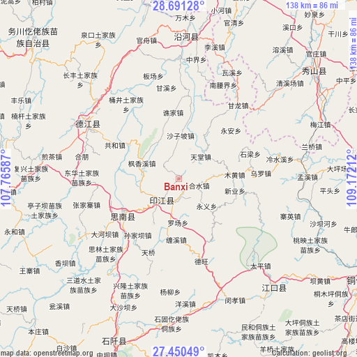
Banxi GPS coordinates[2]
28° 4' 21.648" North, 108° 28' 8.364" East
| Map corner | latitude | longitude |
|---|---|---|
| Upper-left | 28.69128°, | 107.76587° |
| Center: | 28.07268°, | 108.46899° |
| Lower-right: | 27.45049°, | 109.17212° |
| Map W x H: | 138×138 km | = 85.7×85.7mi |
| max Lat: | 53.31946° ⇑73.5% North |
| Banxi: | 28.07268° |
| min Lat: | ⇓26.5% South 18.22056° |
| min Long | Banxi | max Long |
| 75.07348° | 108.46899° | 134.28917° |
| W 21.3%⇐ | ⇒78.7% E |
Elevation
Elevation of Banxi is 587 m = 1926 ft, and this is 102.2 m = 335 ft above average elevation for this country.
| Max E: |
5622 m = 18445 ft | 22.6% |
| Banxi | 587 m 1926 ft | |
| Avg. | 484.8 m = 1591 ft | |
Min E: |
-3 m = -10 ft | 77.4% |
See also: China elevation on elevation.city.
Geographical zone
Banxi is located in North temperate zone (between Tropic of Cancer and the Arctic Circle). Distance of this Northern Tropic circle is 515.5 km =320.3 mi to South.| Distance of | km | miles | from Banxi |
|---|---|---|---|
| North Pole | 6885.7 | 4278.6 | to North |
| Arctic Circle | 4279.8 | 2659.3 | to North |
| Tropic Cancer | 515.5 | 320.3 | to South |
| Equator | 3121.4 | 1939.5 | to South |


Nearby cities:
15 places around Banxi: (largest is in red/bold)
• Changbao
22.8 km =14.2 mi,  304°
304°
• Chaodi
23.4 km =14.5 mi,  277°
277°
• Daoba
21.8 km =13.5 mi,  31°
31°
• Eling
10.4 km =6.5 mi,  219°
219°
• Fengxiangxi
15.5 km =9.6 mi,  293°
293°
• Heshui
8.3 km =5.2 mi,  107°
107°
• Langxi
6.9 km =4.3 mi,  171°
171°
• Muhuang
21.7 km =13.5 mi,  85°
85°
• Qiaojia
25.7 km =16 mi,  355°
355°
• Shanshu
7.1 km =4.4 mi,  307°
307°
• Shazipo
16.8 km =10.4 mi,  2°
2°
• Tiantang
12.6 km =7.8 mi,  45°
45°
• Xinye
22.4 km =13.9 mi,  99°
99°
• Yong’an
27.6 km =17.1 mi, 47°
• Zhongba
14.2 km =8.8 mi,  248°
248°
Sources, notices
• [Note1] Compared only with cities in China existing in our database
• [Src1] Map data: © OpenStreetMap contributors (CC-BY-SA)
• [Src2] Other city data from geonames.org with taken over terms of usage.
• [Src3] Geographical zone / Annual Mean Temperature by Robert A. Rohde @ Wikipedia
