Ganlong geodata
Ganlong (Guizhou) is a seat of a fourth-order administrative division; located in China in Asia/Shanghai (GMT+8) time zone. In our database, there are 1268 cities with bigger population. Compared to other cities in China, 71.2% of cities are located further ↑North; 77.6% of cities are located further →East and 78% of cities have lower elevation than Ganlong. Note1


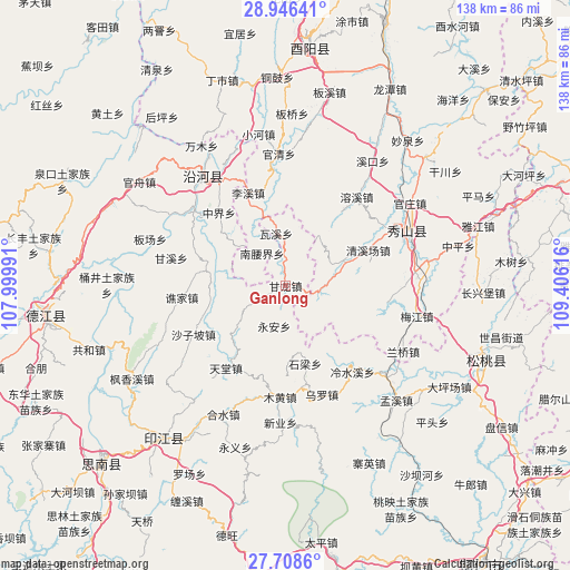
Ganlong GPS coordinates[2]
28° 19' 45.516" North, 108° 42' 10.908" East
| Map corner | latitude | longitude |
|---|---|---|
| Upper-left | 28.94641°, | 107.99991° |
| Center: | 28.32931°, | 108.70303° |
| Lower-right: | 27.7086°, | 109.40616° |
| Map W x H: | 137.6×137.6 km | = 85.5×85.5mi |
| max Lat: | 53.31946° ⇑71.2% North |
| Ganlong: | 28.32931° |
| min Lat: | ⇓28.8% South 18.22056° |
| min Long | Ganlong | max Long |
| 75.07348° | 108.70303° | 134.28917° |
| W 22.4%⇐ | ⇒77.6% E |
Elevation
Elevation of Ganlong is 614 m = 2014 ft, and this is 129.2 m = 424 ft above average elevation for this country.
| Max E: |
5622 m = 18445 ft | 22% |
| Ganlong | 614 m 2014 ft | |
| Avg. | 484.8 m = 1591 ft | |
Min E: |
-3 m = -10 ft | 78% |
See also: China elevation on elevation.city.
Geographical zone
Ganlong is located in North temperate zone (between Tropic of Cancer and the Arctic Circle). Distance of this Northern Tropic circle is 544 km =338 mi to South.| Distance of | km | miles | from Ganlong |
|---|---|---|---|
| North Pole | 6857.1 | 4260.8 | to North |
| Arctic Circle | 4251.3 | 2641.6 | to North |
| Tropic Cancer | 544 | 338 | to South |
| Equator | 3149.9 | 1957.3 | to South |


Nearby cities:
15 places around Ganlong: (largest is in red/bold)
• Aikou
9.8 km =6.1 mi,  89°
89°
• Daoba
15.2 km =9.4 mi,  229°
229°
• Gaotian
22.4 km =13.9 mi,  36°
36°
• Lixi
24.2 km =15 mi,  338°
338°
• Nanyaojie
9.7 km =6 mi,  323°
323°
• Qingxichang
21.4 km =13.3 mi,  67°
67°
• Shazipo
25.2 km =15.7 mi,  242°
242°
• Shiliang
18 km =11.2 mi,  164°
164°
• Tang’ao
12.9 km =8 mi,  56°
56°
• Tiantang
24.1 km =15 mi,  215°
215°
• Waxi
12.8 km =8 mi,  349°
349°
• Xiaojing
16.8 km =10.4 mi,  312°
312°
• Xiaoxi
21.1 km =13.1 mi, 74°
• Yong’an
10.1 km =6.3 mi,  195°
195°
• Zhongjie
21.5 km =13.4 mi, 314°
Sources, notices
• [Note1] Compared only with cities in China existing in our database
• [Src1] Map data: © OpenStreetMap contributors (CC-BY-SA)
• [Src2] Other city data from geonames.org with taken over terms of usage.
• [Src3] Geographical zone / Annual Mean Temperature by Robert A. Rohde @ Wikipedia
