Jingzhou geodata
Jingzhou (Anhui) is a seat of a fourth-order administrative division; located in China in Asia/Shanghai (GMT+8) time zone. In our database, there are 1268 cities with bigger population. Compared to other cities in China, 52.1% of cities are located further ↑North; 75.3% of cities are located further ←West and 79.3% of cities have lower elevation than Jingzhou. Note1


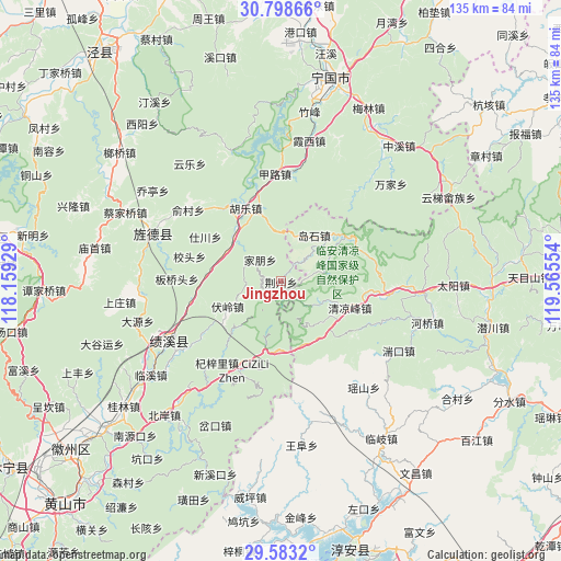
Jingzhou GPS coordinates[2]
30° 11' 34.116" North, 118° 51' 44.676" East
| Map corner | latitude | longitude |
|---|---|---|
| Upper-left | 30.79866°, | 118.15929° |
| Center: | 30.19281°, | 118.86241° |
| Lower-right: | 29.5832°, | 119.56554° |
| Map W x H: | 135.1×135.1 km | = 83.9×83.9mi |
| max Lat: | 53.31946° ⇑52.1% North |
| Jingzhou: | 30.19281° |
| min Lat: | ⇓47.9% South 18.22056° |
| min Long | Jingzhou | max Long |
| 75.07348° | 118.86241° | 134.28917° |
| W 75.3%⇐ | ⇒24.7% E |
Elevation
Elevation of Jingzhou is 660 m = 2165 ft, and this is 175.2 m = 575 ft above average elevation for this country.
| Max E: |
5622 m = 18445 ft | 20.7% |
| Jingzhou | 660 m 2165 ft | |
| Avg. | 484.8 m = 1591 ft | |
Min E: |
-3 m = -10 ft | 79.3% |
See also: China elevation on elevation.city.
Geographical zone
Jingzhou is located in North temperate zone (between Tropic of Cancer and the Arctic Circle). Distance of this Northern Tropic circle is 751.2 km =466.8 mi to South.| Distance of | km | miles | from Jingzhou |
|---|---|---|---|
| North Pole | 6649.9 | 4132.1 | to North |
| Arctic Circle | 4044 | 2512.8 | to North |
| Tropic Cancer | 751.2 | 466.8 | to South |
| Equator | 3357.1 | 2086 | to South |


Nearby cities:
15 places around Jingzhou: (largest is in red/bold)
• Daoshi
13.8 km =8.6 mi,  36°
36°
• Fuling
14.3 km =8.9 mi,  245°
245°
• Hule
19.8 km =12.3 mi,  334°
334°
• Jiapeng
7.4 km =4.6 mi,  315°
315°
• Jinchuan
23.9 km =14.9 mi,  183°
183°
• Jinsha
15 km =9.3 mi,  302°
302°
• Maxiao
10.9 km =6.8 mi,  116°
116°
• Qingliangfeng
17 km =10.6 mi,  110°
110°
• Qizili
24.3 km =15.1 mi,  208°
208°
• Sanyang
20.3 km =12.6 mi,  201°
201°
• Shichuan
21.6 km =13.4 mi, 301°
• Xinqiao
9.3 km =5.8 mi,  45°
45°
• Yangxi
21.6 km =13.4 mi,  259°
259°
• Yutiao
18.7 km =11.6 mi, 54°
• Zhupu
17.5 km =10.9 mi,  189°
189°
Sources, notices
• [Note1] Compared only with cities in China existing in our database
• [Src1] Map data: © OpenStreetMap contributors (CC-BY-SA)
• [Src2] Other city data from geonames.org with taken over terms of usage.
• [Src3] Geographical zone / Annual Mean Temperature by Robert A. Rohde @ Wikipedia
