Zhupu geodata
Zhupu (Anhui) is a seat of a fourth-order administrative division; located in China in Asia/Shanghai (GMT+8) time zone. In our database, there are 1268 cities with bigger population. Compared to other cities in China, 53.6% of cities are located further ↑North; 75.2% of cities are located further ←West and 64.3% of cities have lower elevation than Zhupu. Note1


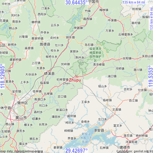
Zhupu GPS coordinates[2]
30° 2' 15.108" North, 118° 49' 55.812" East
| Map corner | latitude | longitude |
|---|---|---|
| Upper-left | 30.64435°, | 118.12905° |
| Center: | 30.03753°, | 118.83217° |
| Lower-right: | 29.42697°, | 119.5353° |
| Map W x H: | 135.4×135.4 km | = 84.1×84.1mi |
| max Lat: | 53.31946° ⇑53.6% North |
| Zhupu: | 30.03753° |
| min Lat: | ⇓46.4% South 18.22056° |
| min Long | Zhupu | max Long |
| 75.07348° | 118.83217° | 134.28917° |
| W 75.2%⇐ | ⇒24.8% E |
Elevation
Elevation of Zhupu is 314 m = 1030 ft, and this is 170.8 m = 560 ft below average elevation for this country.
| Max E: |
5622 m = 18445 ft | 35.7% |
| Avg. | 484.8 m = 1591 ft | |
| Zhupu | 314 m = 1030 ft | |
Min E: |
-3 m = -10 ft | 64.3% |
See also: China elevation on elevation.city.
Geographical zone
Zhupu is located in North temperate zone (between Tropic of Cancer and the Arctic Circle). Distance of this Northern Tropic circle is 733.9 km =456 mi to South.| Distance of | km | miles | from Zhupu |
|---|---|---|---|
| North Pole | 6667.2 | 4142.8 | to North |
| Arctic Circle | 4061.3 | 2523.6 | to North |
| Tropic Cancer | 733.9 | 456 | to South |
| Equator | 3339.9 | 2075.3 | to South |


Nearby cities:
15 places around Zhupu: (largest is in red/bold)
• Chakou
20.6 km =12.8 mi,  216°
216°
• Changxi
22.8 km =14.2 mi,  232°
232°
• Dashe
16.1 km =10 mi,  153°
153°
• Fuling
15.1 km =9.4 mi,  318°
318°
• Jiapeng
22.7 km =14.1 mi,  354°
354°
• Jinchuan
6.7 km =4.2 mi,  168°
168°
• Jingzhou
17.5 km =10.9 mi,  9°
9°
• Maxiao
17.6 km =10.9 mi,  45°
45°
• Qingliangfeng
22 km =13.7 mi,  59°
59°
• Qizili
9.7 km =6 mi,  245°
245°
• Sanyang
5 km =3.1 mi, 251°
• Sucun
13.9 km =8.6 mi,  243°
243°
• Xiakeng
18.5 km =11.5 mi, 241°
• Yangxi
22.6 km =14 mi,  305°
305°
• Yingzhou
18.3 km =11.4 mi,  278°
278°
Sources, notices
• [Note1] Compared only with cities in China existing in our database
• [Src1] Map data: © OpenStreetMap contributors (CC-BY-SA)
• [Src2] Other city data from geonames.org with taken over terms of usage.
• [Src3] Geographical zone / Annual Mean Temperature by Robert A. Rohde @ Wikipedia
