Shichuan geodata
Shichuan (Anhui) is a seat of a fourth-order administrative division; located in China in Asia/Shanghai (GMT+8) time zone. In our database, there are 1268 cities with bigger population. Compared to other cities in China, 51.2% of cities are located further ↑North; 74.3% of cities are located further ←West and 65.2% of cities have lower elevation than Shichuan. Note1


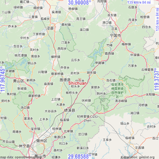
Shichuan GPS coordinates[2]
30° 17' 41.496" North, 118° 40' 14.052" East
| Map corner | latitude | longitude |
|---|---|---|
| Upper-left | 30.90008°, | 117.96745° |
| Center: | 30.29486°, | 118.67057° |
| Lower-right: | 29.68588°, | 119.3737° |
| Map W x H: | 135×135 km | = 83.9×83.9mi |
| max Lat: | 53.31946° ⇑51.2% North |
| Shichuan: | 30.29486° |
| min Lat: | ⇓48.8% South 18.22056° |
| min Long | Shichuan | max Long |
| 75.07348° | 118.67057° | 134.28917° |
| W 74.3%⇐ | ⇒25.7% E |
Elevation
Elevation of Shichuan is 331 m = 1086 ft, and this is 153.8 m = 505 ft below average elevation for this country.
| Max E: |
5622 m = 18445 ft | 34.8% |
| Avg. | 484.8 m = 1591 ft | |
| Shichuan | 331 m = 1086 ft | |
Min E: |
-3 m = -10 ft | 65.2% |
See also: China elevation on elevation.city.
Geographical zone
Shichuan is located in North temperate zone (between Tropic of Cancer and the Arctic Circle). Distance of this Northern Tropic circle is 762.6 km =473.9 mi to South.| Distance of | km | miles | from Shichuan |
|---|---|---|---|
| North Pole | 6638.6 | 4125 | to North |
| Arctic Circle | 4032.7 | 2505.8 | to North |
| Tropic Cancer | 762.6 | 473.9 | to South |
| Equator | 3368.5 | 2093.1 | to South |


Nearby cities:
15 places around Shichuan: (largest is in red/bold)
• Banqiaotou
12.5 km =7.8 mi,  212°
212°
• Banshu
17.6 km =10.9 mi,  245°
245°
• Caijiaqiao
20 km =12.4 mi,  285°
285°
• Fangtang
21.3 km =13.2 mi,  15°
15°
• Fuling
18.2 km =11.3 mi,  162°
162°
• Huatan
13.3 km =8.3 mi, 286°
• Hule
11.8 km =7.3 mi,  56°
56°
• Jiapeng
14.6 km =9.1 mi,  114°
114°
• Jingqiao
8.2 km =5.1 mi, 285°
• Jingyang
12.3 km =7.6 mi,  268°
268°
• Jinsha
6.6 km =4.1 mi,  120°
120°
• Qiaoting
15.8 km =9.8 mi,  311°
311°
• Yangxi
15.6 km =9.7 mi,  190°
190°
• Yucun
7.1 km =4.4 mi,  327°
327°
• Yunle
17.6 km =10.9 mi,  348°
348°
Sources, notices
• [Note1] Compared only with cities in China existing in our database
• [Src1] Map data: © OpenStreetMap contributors (CC-BY-SA)
• [Src2] Other city data from geonames.org with taken over terms of usage.
• [Src3] Geographical zone / Annual Mean Temperature by Robert A. Rohde @ Wikipedia
