Guoziyuan geodata
Guoziyuan (Anhui) is a seat of a fourth-order administrative division; located in China in Asia/Shanghai (GMT+8) time zone. In our database, there are 1268 cities with bigger population. Compared to other cities in China, 57.4% of cities are located further ↓South; 57.6% of cities are located further ←West and 62.5% of cities have lower elevation than Guoziyuan. Note1


Guoziyuan GPS coordinates[2]
31° 20' 30.012" North, 115° 36' 37.008" East
| Map corner | latitude | longitude |
|---|---|---|
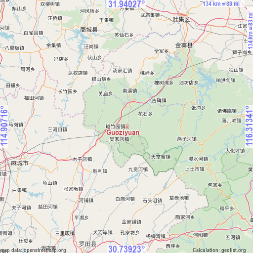
| Upper-left | 31.94027°, | 114.90716° |
| Center: | 31.34167°, | 115.61028° |
| Lower-right: | 30.73923°, | 116.31341° |
| Map W x H: | 133.5×133.5 km | = 83×83mi |
| max Lat: | 53.31946° ⇑42.6% North |
| Guoziyuan: | 31.34167° |
| min Lat: | ⇓57.4% South 18.22056° |
| min Long | Guoziyuan | max Long |
| 75.07348° | 115.61028° | 134.28917° |
| W 57.6%⇐ | ⇒42.4% E |
Elevation
Elevation of Guoziyuan is 289 m = 948 ft, and this is 195.8 m = 642 ft below average elevation for this country.
| Max E: |
5622 m = 18445 ft | 37.5% |
| Avg. | 484.8 m = 1591 ft | |
| Guoziyuan | 289 m = 948 ft | |
Min E: |
-3 m = -10 ft | 62.5% |
See also: China elevation on elevation.city.
Geographical zone
Guoziyuan is located in North temperate zone (between Tropic of Cancer and the Arctic Circle). Distance of this Northern Tropic circle is 878.9 km =546.1 mi to South.| Distance of | km | miles | from Guoziyuan |
|---|---|---|---|
| North Pole | 6522.2 | 4052.7 | to North |
| Arctic Circle | 3916.3 | 2433.5 | to North |
| Tropic Cancer | 878.9 | 546.1 | to South |
| Equator | 3484.9 | 2165.4 | to South |


Nearby cities:
15 places around Guoziyuan: (largest is in red/bold)
• Baimiaohe
37.8 km =23.5 mi,  181°
181°
• Caodipan
46.4 km =28.8 mi,  143°
143°
• Futianhe
51.3 km =31.9 mi,  287°
287°
• Guishan
50.3 km =31.3 mi,  234°
234°
• Hepu
44.3 km =27.5 mi,  209°
209°
• Huangtugang
50.9 km =31.6 mi,  275°
275°
• Jinjiapu
50.1 km =31.1 mi, 177°
• Jiuzihe
23.1 km =14.4 mi,  165°
165°
• Meishan
51.7 km =32.1 mi,  33°
33°
• Muzidian
29.1 km =18.1 mi, 234°
• Sanhekou
36.6 km =22.7 mi,  267°
267°
• Shengli
27.3 km =17 mi, 211°
• Shitouzui
41.1 km =25.5 mi,  160°
160°
• Yanjiahe
49.2 km =30.6 mi,  252°
252°
• Zhangjiafan
43.1 km =26.8 mi,  221°
221°
Sources, notices
• [Note1] Compared only with cities in China existing in our database
• [Src1] Map data: © OpenStreetMap contributors (CC-BY-SA)
• [Src2] Other city data from geonames.org with taken over terms of usage.
• [Src3] Geographical zone / Annual Mean Temperature by Robert A. Rohde @ Wikipedia
