Baimiaohe geodata
Baimiaohe (Hubei) is a seat of a fourth-order administrative division; located in China in Asia/Shanghai (GMT+8) time zone. In our database, there are 1268 cities with bigger population. Compared to other cities in China, 54.9% of cities are located further ↓South; 57.5% of cities are located further ←West and 52.9% of cities have lower elevation than Baimiaohe. Note1


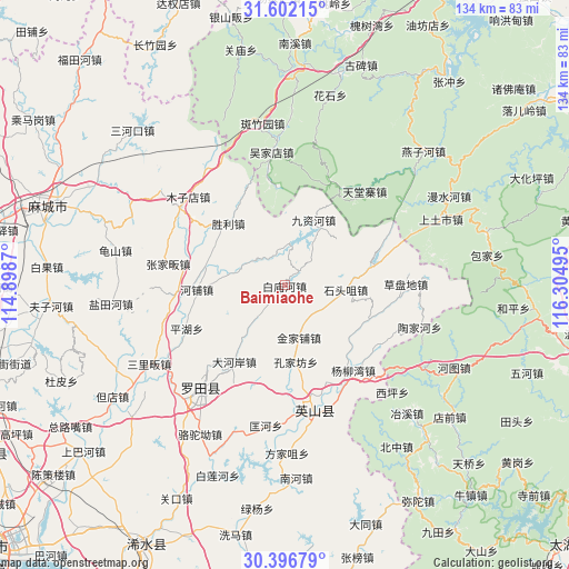
Baimiaohe GPS coordinates[2]
31° 0' 4.932" North, 115° 36' 6.552" East
| Map corner | latitude | longitude |
|---|---|---|
| Upper-left | 31.60215°, | 114.8987° |
| Center: | 31.00137°, | 115.60182° |
| Lower-right: | 30.39679°, | 116.30495° |
| Map W x H: | 134×134 km | = 83.3×83.3mi |
| max Lat: | 53.31946° ⇑45.1% North |
| Baimiaohe: | 31.00137° |
| min Lat: | ⇓54.9% South 18.22056° |
| min Long | Baimiaohe | max Long |
| 75.07348° | 115.60182° | 134.28917° |
| W 57.5%⇐ | ⇒42.5% E |
Elevation
Elevation of Baimiaohe is 188 m = 617 ft, and this is 296.8 m = 974 ft below average elevation for this country.
| Max E: |
5622 m = 18445 ft | 47.1% |
| Avg. | 484.8 m = 1591 ft | |
| Baimiaohe | 188 m = 617 ft | |
Min E: |
-3 m = -10 ft | 52.9% |
See also: China elevation on elevation.city.
Geographical zone
Baimiaohe is located in North temperate zone (between Tropic of Cancer and the Arctic Circle). Distance of this Northern Tropic circle is 841.1 km =522.6 mi to South.| Distance of | km | miles | from Baimiaohe |
|---|---|---|---|
| North Pole | 6560 | 4076.2 | to North |
| Arctic Circle | 3954.1 | 2457 | to North |
| Tropic Cancer | 841.1 | 522.6 | to South |
| Equator | 3447 | 2141.9 | to South |


Nearby cities:
15 places around Baimiaohe: (largest is in red/bold)
• Caodipan
28.3 km =17.6 mi,  89°
89°
• Dahe’an
21.5 km =13.4 mi,  213°
213°
• Fengshan
21.4 km =13.3 mi,  233°
233°
• Hepu
20.9 km =13 mi,  267°
267°
• Hongshan
26.1 km =16.2 mi,  169°
169°
• Jinjiapu
12.6 km =7.8 mi,  164°
164°
• Jiuzihe
16.9 km =10.5 mi,  23°
23°
• Kongjiafang
18.2 km =11.3 mi, 171°
• Leijiadian
19.1 km =11.9 mi,  131°
131°
• Pinghu
25.4 km =15.8 mi,  246°
246°
• Shengli
19.7 km =12.2 mi,  317°
317°
• Shitouzui
14.4 km =8.9 mi, 93°
• Wenquan
19.3 km =12 mi,  151°
151°
• Yangliuwan
25.7 km =16 mi,  141°
141°
• Zhangjiafan
28.2 km =17.5 mi,  281°
281°
Sources, notices
• [Note1] Compared only with cities in China existing in our database
• [Src1] Map data: © OpenStreetMap contributors (CC-BY-SA)
• [Src2] Other city data from geonames.org with taken over terms of usage.
• [Src3] Geographical zone / Annual Mean Temperature by Robert A. Rohde @ Wikipedia
