Zipaquirá geodata
Zipaquirá (Cundinamarca) is a seat of a second-order administrative division; located in Colombia in America/Bogota (GMT-5) time zone. With population of 91,235 people, there are 43 cities with bigger population in this country. Compared to other cities in Colombia, 61.7% of cities are located further ↑North; 64.9% of cities are located further ←West and 93.4% of cities have lower elevation than Zipaquirá. Note1


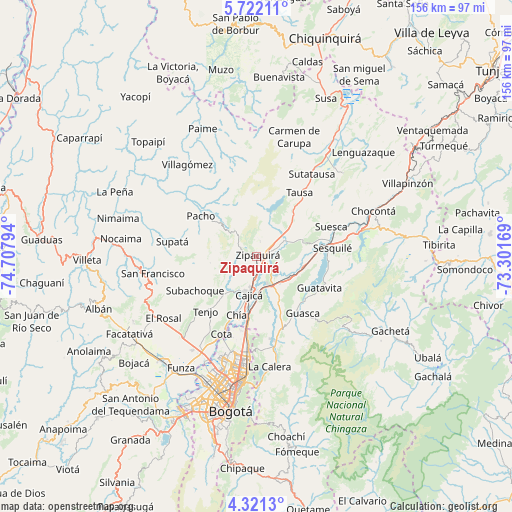
Zipaquirá GPS coordinates[2]
5° 1' 19.488" North, 74° 0' 17.316" West
| Map corner | latitude | longitude |
|---|---|---|
| Upper-left | 5.72211°, | -74.70794° |
| Center: | 5.02208°, | -74.00481° |
| Lower-right: | 4.3213°, | -73.30169° |
| Map W x H: | 155.8×155.8 km | = 96.8×96.8mi |
| max Lat: | 13.38166° ⇑61.7% North |
| Zipaquirá: | 5.02208° |
| min Lat: | ⇓38.3% South -4.21528° |
| min Long | Zipaquirá | max Long |
| -81.70636° | -74.00481° | -67.06996° |
| W 64.9%⇐ | ⇒35.1% E |
Elevation
Elevation of Zipaquirá is 2607 m = 8553 ft, and this is 1457.7 m = 4782 ft above average elevation for this country.
| Max E: |
3342 m = 10965 ft | 6.6% |
| Zipaquirá | 2607 m 8553 ft | |
| Avg. | 1149.3 m = 3771 ft | |
Min E: |
1 m = 3 ft | 93.4% |
See also: Zipaquirá elevation on elevation.city.
Geographical zone
Zipaquirá is located in North Torrid zone (between Equator and Tropic of Cancer). Distance of Equator is 558.4 km =347 mi to South.| Distance of | km | miles | from Zipaquirá |
|---|---|---|---|
| North Pole | 9448.7 | 5871.1 | to North |
| Arctic Circle | 6842.8 | 4251.9 | to North |
| Tropic Cancer | 2047.5 | 1272.3 | to North |
| Equator | 558.4 | 347 | to South |


Nearby cities:
15 places around Zipaquirá: (largest is in red/bold)
• Cajicá
11.8 km =7.3 mi,  192°
192°
• Chía
19.1 km =11.9 mi,  198°
198°
• Cogua
5.1 km =3.2 mi,  33°
33°
• Gachancipá
15.2 km =9.4 mi,  103°
103°
• Guasca
22.4 km =13.9 mi,  140°
140°
• Guatavita
21.3 km =13.2 mi,  116°
116°
• Nemocón
15 km =9.3 mi,  70°
70°
• Pacho
21.1 km =13.1 mi,  305°
305°
• Sesquilé
23.1 km =14.4 mi,  83°
83°
• Sopó
14.7 km =9.1 mi,  149°
149°
• Subachoque
21.5 km =13.4 mi,  240°
240°
• Tabio
15.3 km =9.5 mi,  220°
220°
• Tausa
23.3 km =14.5 mi, 32°
• Tenjo
22.7 km =14.1 mi, 222°
• Tocancipá
12 km =7.5 mi, 121°
Sources, notices
• [Note1] Compared only with cities in Colombia existing in our database
• [Src1] Map data: © OpenStreetMap contributors (CC-BY-SA)
• [Src2] Other city data from geonames.org with taken over terms of usage.
• [Src3] Geographical zone / Annual Mean Temperature by Robert A. Rohde @ Wikipedia
