Sopó geodata
Sopó (Cundinamarca) is a seat of a second-order administrative division; located in Colombia in America/Bogota (GMT-5) time zone. With population of 8,396 people, there are 354 cities with bigger population in this country. Compared to other cities in Colombia, 64.2% of cities are located further ↑North; 66.6% of cities are located further ←West and 92.4% of cities have lower elevation than Sopó. Note1


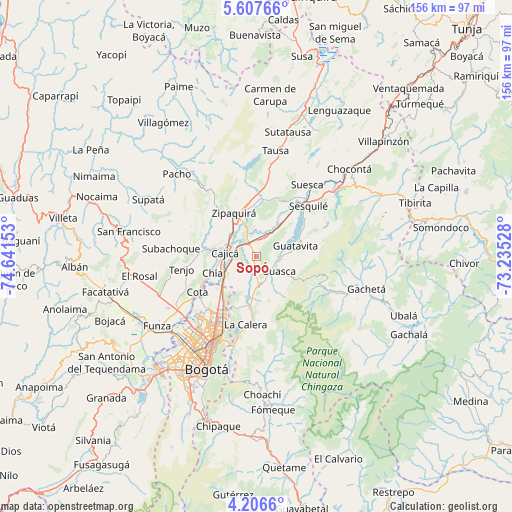
Sopó GPS coordinates[2]
4° 54' 27" North, 73° 56' 18.24" West
| Map corner | latitude | longitude |
|---|---|---|
| Upper-left | 5.60766°, | -74.64153° |
| Center: | 4.9075°, | -73.9384° |
| Lower-right: | 4.2066°, | -73.23528° |
| Map W x H: | 155.8×155.8 km | = 96.8×96.8mi |
| max Lat: | 13.38166° ⇑64.2% North |
| Sopó: | 4.9075° |
| min Lat: | ⇓35.8% South -4.21528° |
| min Long | Sopó | max Long |
| -81.70636° | -73.9384° | -67.06996° |
| W 66.6%⇐ | ⇒33.4% E |
Elevation
Elevation of Sopó is 2584 m = 8478 ft, and this is 1434.7 m = 4707 ft above average elevation for this country.
| Max E: |
3342 m = 10965 ft | 7.6% |
| Sopó | 2584 m 8478 ft | |
| Avg. | 1149.3 m = 3771 ft | |
Min E: |
1 m = 3 ft | 92.4% |
See also: Colombia elevation on elevation.city.
Geographical zone
Sopó is located in North Torrid zone (between Equator and Tropic of Cancer). Distance of Equator is 545.7 km =339.1 mi to South.| Distance of | km | miles | from Sopó |
|---|---|---|---|
| North Pole | 9461.4 | 5879 | to North |
| Arctic Circle | 6855.5 | 4259.8 | to North |
| Tropic Cancer | 2060.3 | 1280.2 | to North |
| Equator | 545.7 | 339.1 | to South |


Nearby cities:
15 places around Sopó: (largest is in red/bold)
• Cajicá
10 km =6.2 mi,  277°
277°
• Chía
14.4 km =8.9 mi,  247°
247°
• Cogua
17.6 km =10.9 mi,  345°
345°
• Cota
20.8 km =12.9 mi,  238°
238°
• Gachancipá
11.9 km =7.4 mi,  38°
38°
• Guasca
8.2 km =5.1 mi,  124°
124°
• Guatavita
12.1 km =7.5 mi,  74°
74°
• La Calera
21.1 km =13.1 mi,  189°
189°
• Nemocón
19 km =11.8 mi,  20°
20°
• Sesquilé
21.8 km =13.5 mi,  45°
45°
• Subachoque
26.1 km =16.2 mi,  274°
274°
• Tabio
17.2 km =10.7 mi, 273°
• Tenjo
23.1 km =14.4 mi,  260°
260°
• Tocancipá
7 km =4.3 mi, 23°
• Zipaquirá
14.7 km =9.1 mi,  329°
329°
Sources, notices
• [Note1] Compared only with cities in Colombia existing in our database
• [Src1] Map data: © OpenStreetMap contributors (CC-BY-SA)
• [Src2] Other city data from geonames.org with taken over terms of usage.
• [Src3] Geographical zone / Annual Mean Temperature by Robert A. Rohde @ Wikipedia
