Nemocón geodata
Nemocón (Cundinamarca) is a seat of a second-order administrative division; located in Colombia in America/Bogota (GMT-5) time zone. With population of 5,466 people, there are 475 cities with bigger population in this country. Compared to other cities in Colombia, 60.4% of cities are located further ↑North; 67.8% of cities are located further ←West and 86.7% of cities have lower elevation than Nemocón. Note1


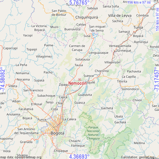
Nemocón GPS coordinates[2]
5° 4' 3.612" North, 73° 52' 39.684" West
| Map corner | latitude | longitude |
|---|---|---|
| Upper-left | 5.76765°, | -74.58082° |
| Center: | 5.06767°, | -73.87769° |
| Lower-right: | 4.36693°, | -73.17457° |
| Map W x H: | 155.7×155.7 km | = 96.7×96.7mi |
| max Lat: | 13.38166° ⇑60.4% North |
| Nemocón: | 5.06767° |
| min Lat: | ⇓39.6% South -4.21528° |
| min Long | Nemocón | max Long |
| -81.70636° | -73.87769° | -67.06996° |
| W 67.8%⇐ | ⇒32.2% E |
Elevation
Elevation of Nemocón is 2397 m = 7864 ft, and this is 1247.7 m = 4094 ft above average elevation for this country.
| Max E: |
3342 m = 10965 ft | 13.3% |
| Nemocón | 2397 m 7864 ft | |
| Avg. | 1149.3 m = 3771 ft | |
Min E: |
1 m = 3 ft | 86.7% |
See also: Colombia elevation on elevation.city.
Geographical zone
Nemocón is located in North Torrid zone (between Equator and Tropic of Cancer). Distance of Equator is 563.5 km =350.1 mi to South.| Distance of | km | miles | from Nemocón |
|---|---|---|---|
| North Pole | 9443.6 | 5868 | to North |
| Arctic Circle | 6837.7 | 4248.7 | to North |
| Tropic Cancer | 2042.4 | 1269.1 | to North |
| Equator | 563.5 | 350.1 | to South |


Nearby cities:
15 places around Nemocón: (largest is in red/bold)
• Cajicá
23.5 km =14.6 mi,  225°
225°
• Chocontá
22.9 km =14.2 mi,  68°
68°
• Cogua
11.3 km =7 mi,  265°
265°
• Cucunubá
23.7 km =14.7 mi,  31°
31°
• Gachancipá
8.5 km =5.3 mi,  175°
175°
• Guasca
22.4 km =13.9 mi, 179°
• Guatavita
15.4 km =9.6 mi,  161°
161°
• La Mesa
22.5 km =14 mi,  348°
348°
• Sesquilé
9.3 km =5.8 mi,  106°
106°
• Sopó
19 km =11.8 mi,  200°
200°
• Suesca
9.6 km =6 mi, 65°
• Sutatausa
20.2 km =12.6 mi,  7°
7°
• Tausa
14.7 km =9.1 mi, 354°
• Tocancipá
12 km =7.5 mi, 198°
• Zipaquirá
15 km =9.3 mi,  250°
250°
Sources, notices
• [Note1] Compared only with cities in Colombia existing in our database
• [Src1] Map data: © OpenStreetMap contributors (CC-BY-SA)
• [Src2] Other city data from geonames.org with taken over terms of usage.
• [Src3] Geographical zone / Annual Mean Temperature by Robert A. Rohde @ Wikipedia
